You are here: Home > Network List > UW - Pacific Northwest Regional Seismic Network Stations List
> Station MRBL Marblemount, WA, USA > Earthquake Result Viewer
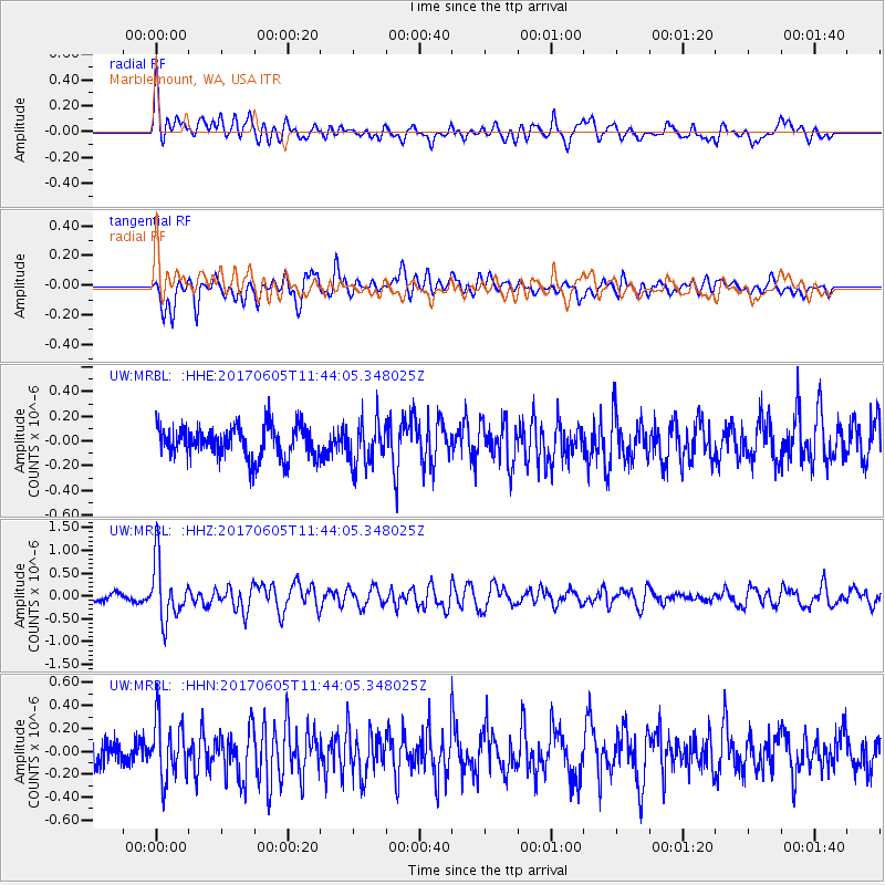
MRBL Marblemount, WA, USA - Earthquake Result Viewer
*The percent match for this event was below the threshold and hence no stack was calculated.
| Earthquake location: |
Peru-Ecuador Border Region |
| Earthquake latitude/longitude: |
-4.1/-80.4 |
| Earthquake time(UTC): |
2017/06/05 (156) 11:34:11 GMT |
| Earthquake Depth: |
51 km |
| Earthquake Magnitude: |
5.6 Mww |
| Earthquake Catalog/Contributor: |
NEIC PDE/us |
|
| Network: |
UW Pacific Northwest Regional Seismic Network |
| Station: |
MRBL Marblemount, WA, USA |
| Lat/Lon: |
48.52 N/121.48 W |
| Elevation: |
75 m |
|
| Distance: |
63.5 deg |
| Az: |
330.757 deg |
| Baz: |
132.871 deg |
| Ray Param: |
$rayparam |
*The percent match for this event was below the threshold and hence was not used in the summary stack. |
|
| Radial Match: |
60.52999 % |
| Radial Bump: |
400 |
| Transverse Match: |
73.11414 % |
| Transverse Bump: |
400 |
| SOD ConfigId: |
13570011 |
| Insert Time: |
2019-04-28 03:48:23.480 +0000 |
| GWidth: |
2.5 |
| Max Bumps: |
400 |
| Tol: |
0.001 |
|
Signal To Noise
| Channel | StoN | STA | LTA |
| UW:MRBL: :HHZ:20170605T11:44:05.348025Z | 6.3184676 | 6.405357E-7 | 1.0137517E-7 |
| UW:MRBL: :HHN:20170605T11:44:05.348025Z | 2.6055937 | 2.510957E-7 | 9.6367955E-8 |
| UW:MRBL: :HHE:20170605T11:44:05.348025Z | 1.3717791 | 1.7375223E-7 | 1.2666196E-7 |
| Arrivals |
| Ps | |
| PpPs | |
| PsPs/PpSs | |


