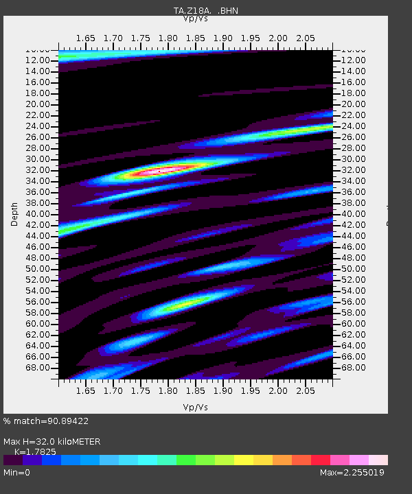
Z18A Geronimo, AZ, USA - Earthquake Result Viewer

Earthquake location: Andreanof Islands, Aleutian Is.
Earthquake latitude/longitude: 51.9/-179.4
Earthquake time(UTC): 2008/04/15 (106) 22:59:51 GMT
Earthquake Depth: 10 km
Earthquake Magnitude: 6.1 MB, 6.4 MS, 6.4 MW, 6.4 MW
Earthquake Catalog/Contributor: WHDF/NEIC
Network: TA USArray Transportable Network (new EarthScope stations)
Station: Z18A Geronimo, AZ, USA
Lat/Lon: 33.09 N/110.04 W
Elevation: 812 m
Distance: 52.4 deg
Az: 82.426 deg
Baz: 312.917 deg
Ray Param: 0.06677954
Estimated Moho Depth: 32.0 km
Estimated Crust Vp/Vs: 1.78
Assumed Crust Vp: 6.276 km/s
Estimated Crust Vs: 3.521 km/s
Estimated Crust Poisson's Ratio: 0.27
Radial Match: 90.89422 %
Radial Bump: 400
Transverse Match: 82.204895 %
Transverse Bump: 400
SOD ConfigId: 2504
Insert Time: 2010-03-06 00:30:31.058 +0000
GWidth: 2.5
Max Bumps: 400
Tol: 0.001

Signal To Noise

ChannelStoNSTALTA
TA:Z18A: :BHN:20080415T23:08:32.774011Z9.09989552.09912E-62.3067517E-7
TA:Z18A: :BHE:20080415T23:08:32.774011Z2.5000278.54798E-73.419155E-7
TA:Z18A: :BHZ:20080415T23:08:32.774011Z3.90555521.1120342E-62.8473136E-7
Arrivals
Ps4.2 SECOND
PpPs13 SECOND
PsPs/PpSs18 SECOND