You are here: Home > Network List > TA - USArray Transportable Network (new EarthScope stations) Stations List
> Station Z18A Geronimo, AZ, USA > Earthquake Result Viewer
Z18A Geronimo, AZ, USA - Earthquake Result Viewer
| Earthquake location: |
Hokkaido, Japan Region |
| Earthquake latitude/longitude: |
41.5/139.0 |
| Earthquake time(UTC): |
2008/06/04 (156) 17:03:07 GMT |
| Earthquake Depth: |
213 km |
| Earthquake Magnitude: |
5.5 MB, 5.7 MW, 5.7 MW |
| Earthquake Catalog/Contributor: |
WHDF/NEIC |
|
| Network: |
TA USArray Transportable Network (new EarthScope stations) |
| Station: |
Z18A Geronimo, AZ, USA |
| Lat/Lon: |
33.09 N/110.04 W |
| Elevation: |
812 m |
|
| Distance: |
82.3 deg |
| Az: |
52.31 deg |
| Baz: |
314.955 deg |
| Ray Param: |
0.046459753 |
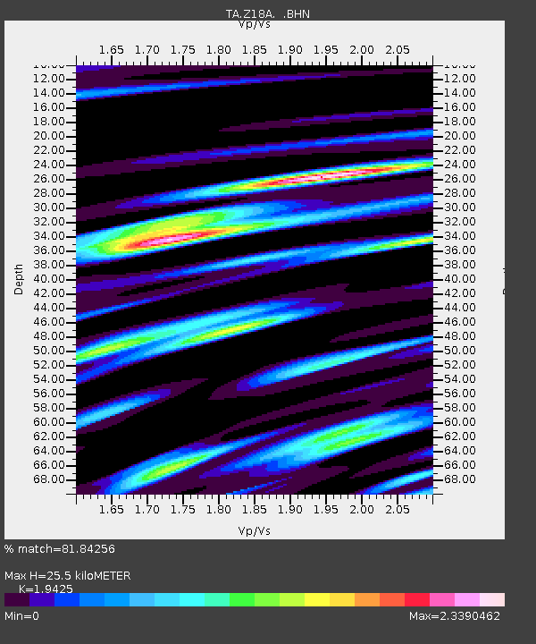
| Estimated Moho Depth: |
25.5 km |
| Estimated Crust Vp/Vs: |
1.94 |
| Assumed Crust Vp: |
6.276 km/s |
| Estimated Crust Vs: |
3.231 km/s |
| Estimated Crust Poisson's Ratio: |
0.32 |
|
| Radial Match: |
81.84256 % |
| Radial Bump: |
400 |
| Transverse Match: |
74.198395 % |
| Transverse Bump: |
400 |
| SOD ConfigId: |
2504 |
| Insert Time: |
2010-03-06 00:30:38.828 +0000 |
| GWidth: |
2.5 |
| Max Bumps: |
400 |
| Tol: |
0.001 |
|

Signal To Noise
| Channel | StoN | STA | LTA |
| TA:Z18A: :BHN:20080604T17:14:33.950Z | 9.606168 | 8.9027304E-7 | 9.267723E-8 |
| TA:Z18A: :BHE:20080604T17:14:33.950Z | 1.5365351 | 2.4467118E-7 | 1.5923565E-7 |
| TA:Z18A: :BHZ:20080604T17:14:33.950Z | 3.6727872 | 5.1212373E-7 | 1.3943736E-7 |
| Arrivals |
| Ps | 3.9 SECOND |
| PpPs | 12 SECOND |
| PsPs/PpSs | 16 SECOND |


