You are here: Home > Network List > TA - USArray Transportable Network (new EarthScope stations) Stations List
> Station Z18A Geronimo, AZ, USA > Earthquake Result Viewer
Z18A Geronimo, AZ, USA - Earthquake Result Viewer
| Earthquake location: |
North Of Severnaya Zemlya |
| Earthquake latitude/longitude: |
83.6/115.2 |
| Earthquake time(UTC): |
2008/08/13 (226) 08:35:02 GMT |
| Earthquake Depth: |
10 km |
| Earthquake Magnitude: |
5.5 MB, 4.7 MS, 5.4 MW, 5.4 MW |
| Earthquake Catalog/Contributor: |
WHDF/NEIC |
|
| Network: |
TA USArray Transportable Network (new EarthScope stations) |
| Station: |
Z18A Geronimo, AZ, USA |
| Lat/Lon: |
33.09 N/110.04 W |
| Elevation: |
812 m |
|
| Distance: |
61.7 deg |
| Az: |
42.65 deg |
| Baz: |
354.838 deg |
| Ray Param: |
0.060706 |
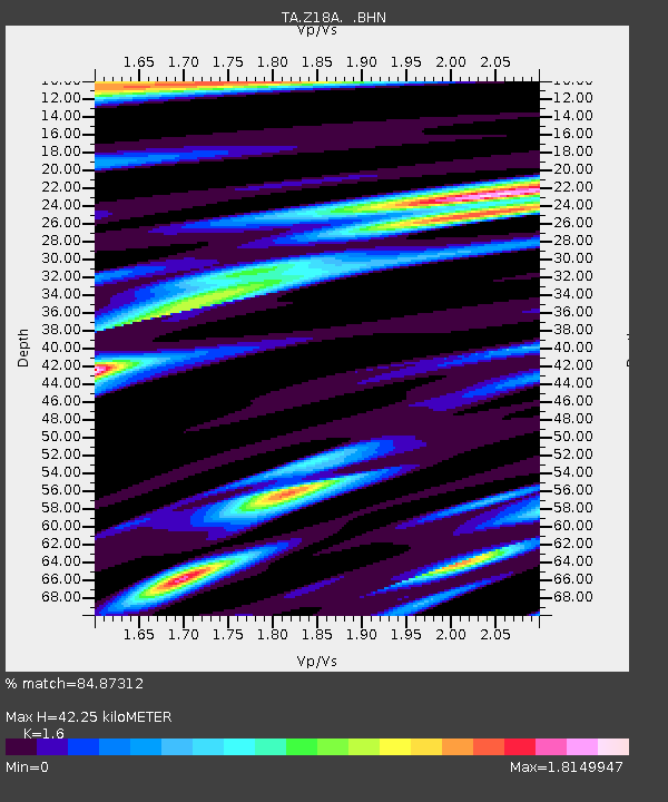
| Estimated Moho Depth: |
42.25 km |
| Estimated Crust Vp/Vs: |
1.60 |
| Assumed Crust Vp: |
6.276 km/s |
| Estimated Crust Vs: |
3.922 km/s |
| Estimated Crust Poisson's Ratio: |
0.18 |
|
| Radial Match: |
84.87312 % |
| Radial Bump: |
400 |
| Transverse Match: |
77.15873 % |
| Transverse Bump: |
400 |
| SOD ConfigId: |
2504 |
| Insert Time: |
2010-03-06 00:30:52.065 +0000 |
| GWidth: |
2.5 |
| Max Bumps: |
400 |
| Tol: |
0.001 |
|
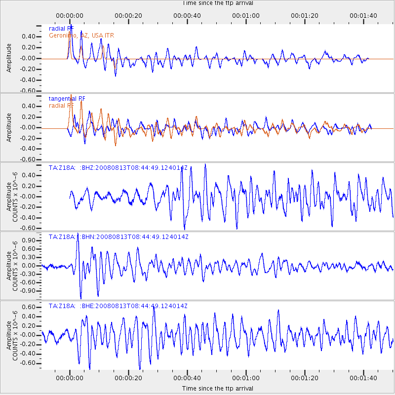
Signal To Noise
| Channel | StoN | STA | LTA |
| TA:Z18A: :BHN:20080813T08:44:49.124014Z | 10.367718 | 5.083177E-7 | 4.90289E-8 |
| TA:Z18A: :BHE:20080813T08:44:49.124014Z | 2.8649702 | 2.3552501E-7 | 8.220854E-8 |
| TA:Z18A: :BHZ:20080813T08:44:49.124014Z | 1.9720659 | 1.830967E-7 | 9.284512E-8 |
| Arrivals |
| Ps | 4.2 SECOND |
| PpPs | 17 SECOND |
| PsPs/PpSs | 21 SECOND |


