You are here: Home > Network List > YX16 - Raton Basin UNM Broadband Network Stations List
> Station UNM7 NW Corner of CO Stations > Earthquake Result Viewer
UNM7 NW Corner of CO Stations - Earthquake Result Viewer
| Earthquake location: |
Peru-Ecuador Border Region |
| Earthquake latitude/longitude: |
-4.1/-80.4 |
| Earthquake time(UTC): |
2017/06/05 (156) 11:34:11 GMT |
| Earthquake Depth: |
51 km |
| Earthquake Magnitude: |
5.6 Mww |
| Earthquake Catalog/Contributor: |
NEIC PDE/us |
|
| Network: |
YX Raton Basin UNM Broadband Network |
| Station: |
UNM7 NW Corner of CO Stations |
| Lat/Lon: |
37.29 N/104.94 W |
| Elevation: |
2639 m |
|
| Distance: |
47.1 deg |
| Az: |
333.099 deg |
| Baz: |
145.539 deg |
| Ray Param: |
0.07007507 |
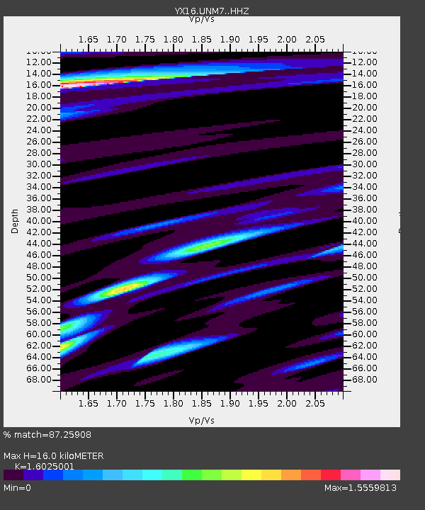
| Estimated Moho Depth: |
16.0 km |
| Estimated Crust Vp/Vs: |
1.60 |
| Assumed Crust Vp: |
6.316 km/s |
| Estimated Crust Vs: |
3.941 km/s |
| Estimated Crust Poisson's Ratio: |
0.18 |
|
| Radial Match: |
87.25908 % |
| Radial Bump: |
362 |
| Transverse Match: |
69.712685 % |
| Transverse Bump: |
400 |
| SOD ConfigId: |
13570011 |
| Insert Time: |
2019-04-28 03:49:56.443 +0000 |
| GWidth: |
2.5 |
| Max Bumps: |
400 |
| Tol: |
0.001 |
|

Signal To Noise
| Channel | StoN | STA | LTA |
| YX:UNM7: :HHZ:20170605T11:42:07.760012Z | 19.479439 | 1.0488355E-6 | 5.3843213E-8 |
| YX:UNM7: :HHN:20170605T11:42:07.760012Z | 3.6048517 | 3.9379427E-7 | 1.0924008E-7 |
| YX:UNM7: :HHE:20170605T11:42:07.760012Z | 1.5543512 | 1.4211618E-7 | 9.14312E-8 |
| Arrivals |
| Ps | 1.6 SECOND |
| PpPs | 6.2 SECOND |
| PsPs/PpSs | 7.8 SECOND |


