You are here: Home > Network List > TA - USArray Transportable Network (new EarthScope stations) Stations List
> Station Z18A Geronimo, AZ, USA > Earthquake Result Viewer
Z18A Geronimo, AZ, USA - Earthquake Result Viewer
| Earthquake location: |
Panama-Costa Rica Border Region |
| Earthquake latitude/longitude: |
8.3/-83.0 |
| Earthquake time(UTC): |
2008/11/19 (324) 06:11:20 GMT |
| Earthquake Depth: |
32 km |
| Earthquake Magnitude: |
5.9 MB, 5.9 MS, 6.2 MW, 6.1 MW |
| Earthquake Catalog/Contributor: |
WHDF/NEIC |
|
| Network: |
TA USArray Transportable Network (new EarthScope stations) |
| Station: |
Z18A Geronimo, AZ, USA |
| Lat/Lon: |
33.09 N/110.04 W |
| Elevation: |
812 m |
|
| Distance: |
35.2 deg |
| Az: |
318.443 deg |
| Baz: |
128.55 deg |
| Ray Param: |
0.07731025 |
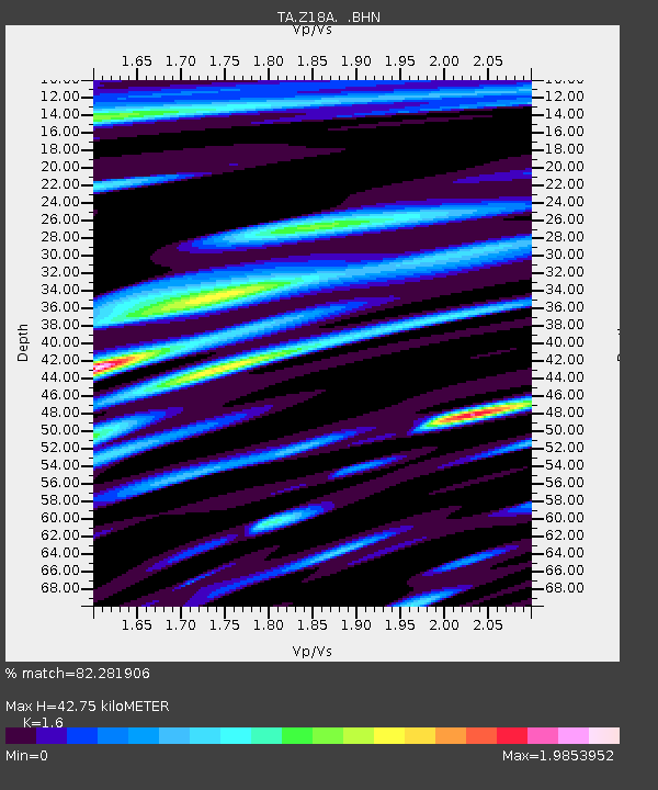
| Estimated Moho Depth: |
42.75 km |
| Estimated Crust Vp/Vs: |
1.60 |
| Assumed Crust Vp: |
6.276 km/s |
| Estimated Crust Vs: |
3.922 km/s |
| Estimated Crust Poisson's Ratio: |
0.18 |
|
| Radial Match: |
82.281906 % |
| Radial Bump: |
400 |
| Transverse Match: |
72.991974 % |
| Transverse Bump: |
400 |
| SOD ConfigId: |
2658 |
| Insert Time: |
2010-03-06 00:31:24.850 +0000 |
| GWidth: |
2.5 |
| Max Bumps: |
400 |
| Tol: |
0.001 |
|
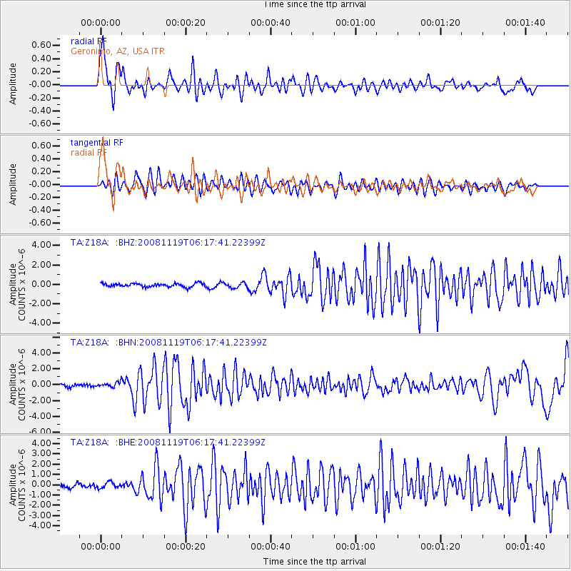
Signal To Noise
| Channel | StoN | STA | LTA |
| TA:Z18A: :BHN:20081119T06:17:41.22399Z | 1.8644115 | 3.2030337E-7 | 1.7179865E-7 |
| TA:Z18A: :BHE:20081119T06:17:41.22399Z | 1.1468471 | 2.879369E-7 | 2.5106823E-7 |
| TA:Z18A: :BHZ:20081119T06:17:41.22399Z | 1.5294958 | 2.708722E-7 | 1.77099E-7 |
| Arrivals |
| Ps | 4.4 SECOND |
| PpPs | 16 SECOND |
| PsPs/PpSs | 21 SECOND |


