You are here: Home > Network List > US - United States National Seismic Network Stations List
> Station DUG Dugway, Tooele County, Utah, USA > Earthquake Result Viewer
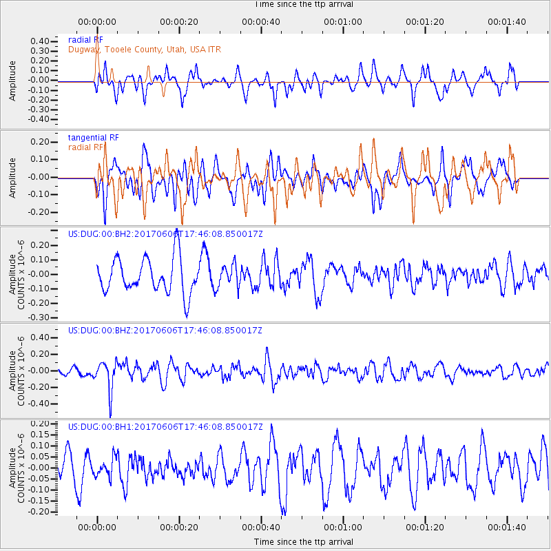
DUG Dugway, Tooele County, Utah, USA - Earthquake Result Viewer
*The percent match for this event was below the threshold and hence no stack was calculated.
| Earthquake location: |
Northern Chile |
| Earthquake latitude/longitude: |
-22.9/-68.6 |
| Earthquake time(UTC): |
2017/06/06 (157) 17:35:08 GMT |
| Earthquake Depth: |
97 km |
| Earthquake Magnitude: |
5.3 Mww |
| Earthquake Catalog/Contributor: |
NEIC PDE/us |
|
| Network: |
US United States National Seismic Network |
| Station: |
DUG Dugway, Tooele County, Utah, USA |
| Lat/Lon: |
40.19 N/112.81 W |
| Elevation: |
1477 m |
|
| Distance: |
75.1 deg |
| Az: |
326.453 deg |
| Baz: |
138.3 deg |
| Ray Param: |
$rayparam |
*The percent match for this event was below the threshold and hence was not used in the summary stack. |
|
| Radial Match: |
56.641243 % |
| Radial Bump: |
400 |
| Transverse Match: |
38.9839 % |
| Transverse Bump: |
400 |
| SOD ConfigId: |
13570011 |
| Insert Time: |
2019-04-28 03:55:54.518 +0000 |
| GWidth: |
2.5 |
| Max Bumps: |
400 |
| Tol: |
0.001 |
|
Signal To Noise
| Channel | StoN | STA | LTA |
| US:DUG:00:BHZ:20170606T17:46:08.850017Z | 3.6796744 | 1.7794964E-7 | 4.836016E-8 |
| US:DUG:00:BH1:20170606T17:46:08.850017Z | 0.7417041 | 4.1736467E-8 | 5.6271052E-8 |
| US:DUG:00:BH2:20170606T17:46:08.850017Z | 0.623434 | 7.4727545E-8 | 1.1986441E-7 |
| Arrivals |
| Ps | |
| PpPs | |
| PsPs/PpSs | |


