You are here: Home > Network List > TA - USArray Transportable Network (new EarthScope stations) Stations List
> Station Z18A Geronimo, AZ, USA > Earthquake Result Viewer
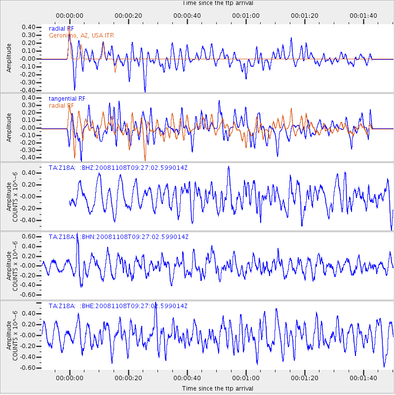
Z18A Geronimo, AZ, USA - Earthquake Result Viewer
*The percent match for this event was below the threshold and hence no stack was calculated.
| Earthquake location: |
Tonga Islands |
| Earthquake latitude/longitude: |
-15.2/-174.2 |
| Earthquake time(UTC): |
2008/11/08 (313) 09:15:51 GMT |
| Earthquake Depth: |
140 km |
| Earthquake Magnitude: |
5.5 MW, 5.3 MB |
| Earthquake Catalog/Contributor: |
WHDF/NEIC |
|
| Network: |
TA USArray Transportable Network (new EarthScope stations) |
| Station: |
Z18A Geronimo, AZ, USA |
| Lat/Lon: |
33.09 N/110.04 W |
| Elevation: |
812 m |
|
| Distance: |
77.8 deg |
| Az: |
50.637 deg |
| Baz: |
242.753 deg |
| Ray Param: |
$rayparam |
*The percent match for this event was below the threshold and hence was not used in the summary stack. |
|
| Radial Match: |
50.882446 % |
| Radial Bump: |
400 |
| Transverse Match: |
57.7277 % |
| Transverse Bump: |
400 |
| SOD ConfigId: |
2658 |
| Insert Time: |
2010-03-06 00:32:40.263 +0000 |
| GWidth: |
2.5 |
| Max Bumps: |
400 |
| Tol: |
0.001 |
|
Signal To Noise
| Channel | StoN | STA | LTA |
| TA:Z18A: :BHN:20081108T09:27:02.599014Z | 2.321758 | 2.6571325E-7 | 1.14444845E-7 |
| TA:Z18A: :BHE:20081108T09:27:02.599014Z | 1.3741728 | 1.8748821E-7 | 1.3643714E-7 |
| TA:Z18A: :BHZ:20081108T09:27:02.599014Z | 0.7785727 | 1.5222004E-7 | 1.9551167E-7 |
| Arrivals |
| Ps | |
| PpPs | |
| PsPs/PpSs | |


