You are here: Home > Network List > GM - US Geological Survey Networks Stations List
> Station IWM01 Jericho 2M Well Monitoring Station > Earthquake Result Viewer
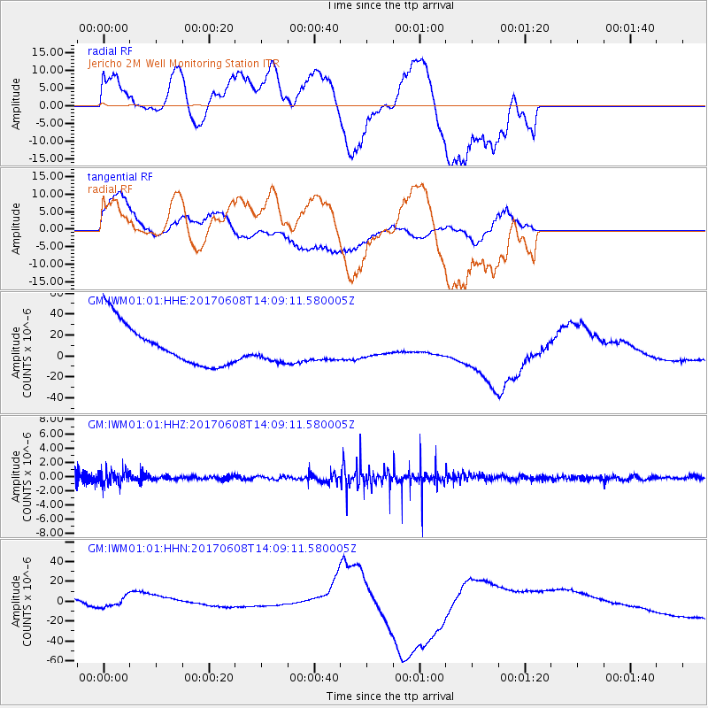
IWM01 Jericho 2M Well Monitoring Station - Earthquake Result Viewer
*The percent match for this event was below the threshold and hence no stack was calculated.
| Earthquake location: |
Northern Peru |
| Earthquake latitude/longitude: |
-8.0/-75.9 |
| Earthquake time(UTC): |
2017/06/08 (159) 14:01:09 GMT |
| Earthquake Depth: |
108 km |
| Earthquake Magnitude: |
5.2 Mww |
| Earthquake Catalog/Contributor: |
NEIC PDE/us |
|
| Network: |
GM US Geological Survey Networks |
| Station: |
IWM01 Jericho 2M Well Monitoring Station |
| Lat/Lon: |
36.73 N/96.53 W |
| Elevation: |
328 m |
|
| Distance: |
48.5 deg |
| Az: |
337.758 deg |
| Baz: |
152.185 deg |
| Ray Param: |
$rayparam |
*The percent match for this event was below the threshold and hence was not used in the summary stack. |
|
| Radial Match: |
20.42531 % |
| Radial Bump: |
341 |
| Transverse Match: |
53.50374 % |
| Transverse Bump: |
365 |
| SOD ConfigId: |
13570011 |
| Insert Time: |
2019-04-28 03:59:49.318 +0000 |
| GWidth: |
2.5 |
| Max Bumps: |
400 |
| Tol: |
0.001 |
|
Signal To Noise
| Channel | StoN | STA | LTA |
| GM:IWM01:01:HHZ:20170608T14:09:11.580005Z | 1.1573199 | 9.398188E-7 | 8.120648E-7 |
| GM:IWM01:01:HHN:20170608T14:09:11.580005Z | 0.42366648 | 1.0592305E-5 | 2.5001518E-5 |
| GM:IWM01:01:HHE:20170608T14:09:11.580005Z | 0.6725547 | 1.3352197E-5 | 1.9852954E-5 |
| Arrivals |
| Ps | |
| PpPs | |
| PsPs/PpSs | |


