You are here: Home > Network List > TA - USArray Transportable Network (new EarthScope stations) Stations List
> Station M14A Sheep Mountain BLM, Rosette, UT, USA > Earthquake Result Viewer
M14A Sheep Mountain BLM, Rosette, UT, USA - Earthquake Result Viewer

| Earthquake location: |
Loyalty Islands |
| Earthquake latitude/longitude: |
-20.1/168.9 |
| Earthquake time(UTC): |
2008/04/09 (100) 12:46:12 GMT |
| Earthquake Depth: |
33 km |
| Earthquake Magnitude: |
6.3 MB, 7.3 MS, 7.3 MW, 7.3 MW |
| Earthquake Catalog/Contributor: |
WHDF/NEIC |
|
| Network: |
TA USArray Transportable Network (new EarthScope stations) |
| Station: |
M14A Sheep Mountain BLM, Rosette, UT, USA |
| Lat/Lon: |
41.50 N/113.35 W |
| Elevation: |
1318 m |
|
| Distance: |
94.3 deg |
| Az: |
47.405 deg |
| Baz: |
247.113 deg |
| Ray Param: |
0.041055456 |
| Estimated Moho Depth: |
64.75 km |
| Estimated Crust Vp/Vs: |
2.10 |
| Assumed Crust Vp: |
6.276 km/s |
| Estimated Crust Vs: |
2.992 km/s |
| Estimated Crust Poisson's Ratio: |
0.35 |
|
| Radial Match: |
95.74007 % |
| Radial Bump: |
261 |
| Transverse Match: |
90.79488 % |
| Transverse Bump: |
267 |
| SOD ConfigId: |
2504 |
| Insert Time: |
2010-03-06 00:33:03.356 +0000 |
| GWidth: |
2.5 |
| Max Bumps: |
400 |
| Tol: |
0.001 |
|
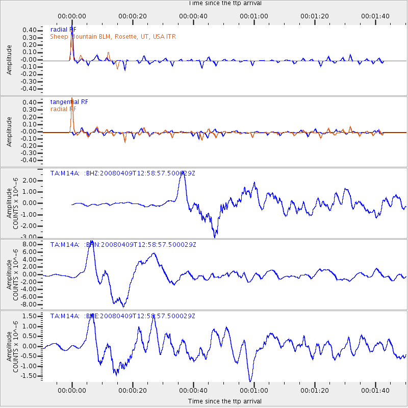
Signal To Noise
| Channel | StoN | STA | LTA |
| TA:M14A: :BHN:20080409T12:58:57.500029Z | 4.6239285 | 1.1523783E-6 | 2.4922062E-7 |
| TA:M14A: :BHE:20080409T12:58:57.500029Z | 1.1324512 | 1.6623241E-7 | 1.4678992E-7 |
| TA:M14A: :BHZ:20080409T12:58:57.500029Z | 3.3173976 | 3.1242936E-7 | 9.417906E-8 |
| Arrivals |
| Ps | 12 SECOND |
| PpPs | 31 SECOND |
| PsPs/PpSs | 43 SECOND |


