You are here: Home > Network List > TA - USArray Transportable Network (new EarthScope stations) Stations List
> Station M14A Sheep Mountain BLM, Rosette, UT, USA > Earthquake Result Viewer
M14A Sheep Mountain BLM, Rosette, UT, USA - Earthquake Result Viewer
| Earthquake location: |
Near East Coast Of Honshu, Japan |
| Earthquake latitude/longitude: |
36.2/141.8 |
| Earthquake time(UTC): |
2008/05/07 (128) 16:16:36 GMT |
| Earthquake Depth: |
23 km |
| Earthquake Magnitude: |
5.9 MB, 6.1 MW, 6.0 MW |
| Earthquake Catalog/Contributor: |
WHDF/NEIC |
|
| Network: |
TA USArray Transportable Network (new EarthScope stations) |
| Station: |
M14A Sheep Mountain BLM, Rosette, UT, USA |
| Lat/Lon: |
41.50 N/113.35 W |
| Elevation: |
1318 m |
|
| Distance: |
76.6 deg |
| Az: |
48.258 deg |
| Baz: |
306.492 deg |
| Ray Param: |
0.050850034 |
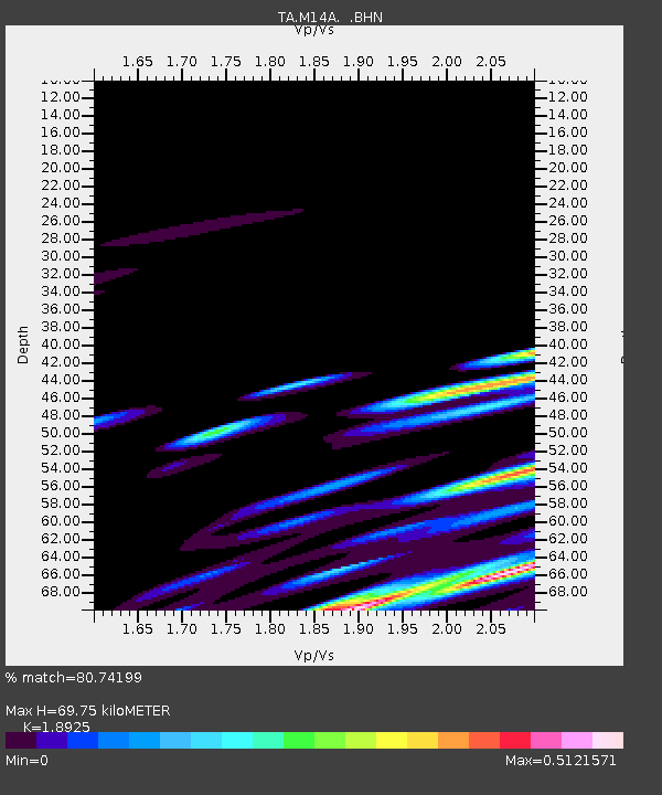
| Estimated Moho Depth: |
69.75 km |
| Estimated Crust Vp/Vs: |
1.89 |
| Assumed Crust Vp: |
6.276 km/s |
| Estimated Crust Vs: |
3.316 km/s |
| Estimated Crust Poisson's Ratio: |
0.31 |
|
| Radial Match: |
80.74199 % |
| Radial Bump: |
400 |
| Transverse Match: |
63.238697 % |
| Transverse Bump: |
400 |
| SOD ConfigId: |
2504 |
| Insert Time: |
2010-03-06 00:33:10.628 +0000 |
| GWidth: |
2.5 |
| Max Bumps: |
400 |
| Tol: |
0.001 |
|
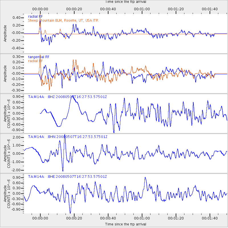
Signal To Noise
| Channel | StoN | STA | LTA |
| TA:M14A: :BHN:20080507T16:27:53.57501Z | 1.433831 | 7.754631E-7 | 5.4083296E-7 |
| TA:M14A: :BHE:20080507T16:27:53.57501Z | 0.90222317 | 1.7613438E-7 | 1.9522264E-7 |
| TA:M14A: :BHZ:20080507T16:27:53.57501Z | 0.77078855 | 3.4902385E-7 | 4.5281402E-7 |
| Arrivals |
| Ps | 10 SECOND |
| PpPs | 31 SECOND |
| PsPs/PpSs | 41 SECOND |


