You are here: Home > Network List > TA - USArray Transportable Network (new EarthScope stations) Stations List
> Station M14A Sheep Mountain BLM, Rosette, UT, USA > Earthquake Result Viewer
M14A Sheep Mountain BLM, Rosette, UT, USA - Earthquake Result Viewer
| Earthquake location: |
South Of Mariana Islands |
| Earthquake latitude/longitude: |
12.5/143.2 |
| Earthquake time(UTC): |
2008/05/09 (130) 21:51:29 GMT |
| Earthquake Depth: |
76 km |
| Earthquake Magnitude: |
6.1 MB, 6.7 MW, 6.7 MW |
| Earthquake Catalog/Contributor: |
WHDF/NEIC |
|
| Network: |
TA USArray Transportable Network (new EarthScope stations) |
| Station: |
M14A Sheep Mountain BLM, Rosette, UT, USA |
| Lat/Lon: |
41.50 N/113.35 W |
| Elevation: |
1318 m |
|
| Distance: |
91.6 deg |
| Az: |
46.95 deg |
| Baz: |
288.183 deg |
| Ray Param: |
0.041548777 |
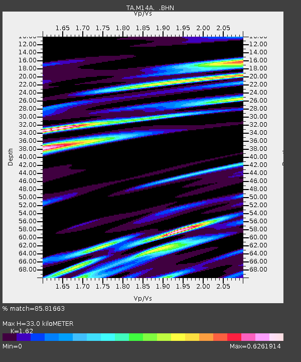
| Estimated Moho Depth: |
33.0 km |
| Estimated Crust Vp/Vs: |
1.62 |
| Assumed Crust Vp: |
6.276 km/s |
| Estimated Crust Vs: |
3.874 km/s |
| Estimated Crust Poisson's Ratio: |
0.19 |
|
| Radial Match: |
85.81663 % |
| Radial Bump: |
400 |
| Transverse Match: |
78.579796 % |
| Transverse Bump: |
400 |
| SOD ConfigId: |
2504 |
| Insert Time: |
2010-03-06 00:33:12.901 +0000 |
| GWidth: |
2.5 |
| Max Bumps: |
400 |
| Tol: |
0.001 |
|
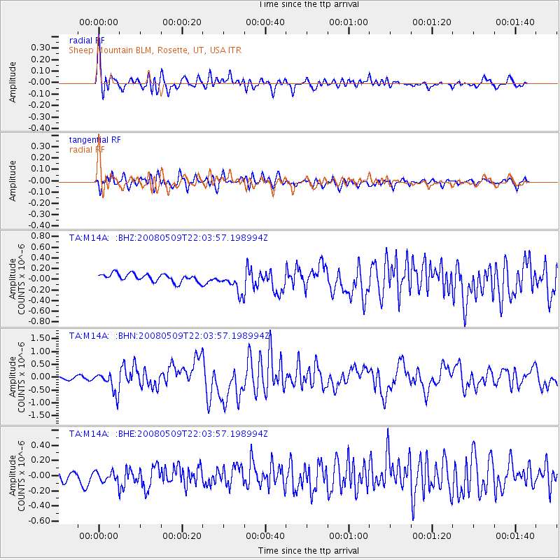
Signal To Noise
| Channel | StoN | STA | LTA |
| TA:M14A: :BHN:20080509T22:03:57.198994Z | 6.050115 | 4.2983757E-7 | 7.104618E-8 |
| TA:M14A: :BHE:20080509T22:03:57.198994Z | 1.1781789 | 7.671202E-8 | 6.511067E-8 |
| TA:M14A: :BHZ:20080509T22:03:57.198994Z | 2.871033 | 2.1305283E-7 | 7.4207726E-8 |
| Arrivals |
| Ps | 3.3 SECOND |
| PpPs | 13 SECOND |
| PsPs/PpSs | 17 SECOND |


