You are here: Home > Network List > TA - USArray Transportable Network (new EarthScope stations) Stations List
> Station M14A Sheep Mountain BLM, Rosette, UT, USA > Earthquake Result Viewer
M14A Sheep Mountain BLM, Rosette, UT, USA - Earthquake Result Viewer
| Earthquake location: |
Off East Coast Of Honshu, Japan |
| Earthquake latitude/longitude: |
37.6/142.2 |
| Earthquake time(UTC): |
2008/07/19 (201) 02:39:28 GMT |
| Earthquake Depth: |
22 km |
| Earthquake Magnitude: |
6.2 MB, 7.0 MS, 7.0 MW, 6.9 MW |
| Earthquake Catalog/Contributor: |
WHDF/NEIC |
|
| Network: |
TA USArray Transportable Network (new EarthScope stations) |
| Station: |
M14A Sheep Mountain BLM, Rosette, UT, USA |
| Lat/Lon: |
41.50 N/113.35 W |
| Elevation: |
1318 m |
|
| Distance: |
75.4 deg |
| Az: |
48.731 deg |
| Baz: |
307.317 deg |
| Ray Param: |
0.0516606 |
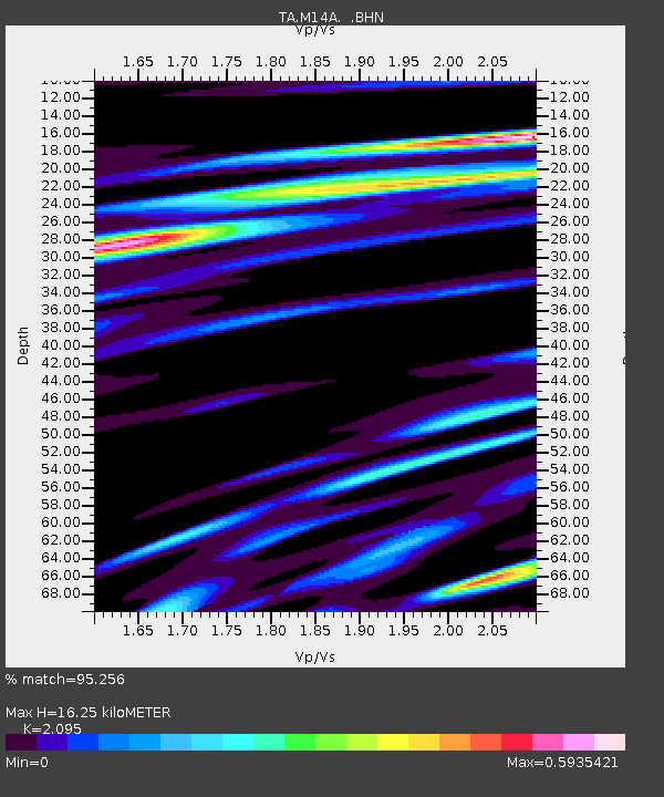
| Estimated Moho Depth: |
16.25 km |
| Estimated Crust Vp/Vs: |
2.10 |
| Assumed Crust Vp: |
6.276 km/s |
| Estimated Crust Vs: |
2.996 km/s |
| Estimated Crust Poisson's Ratio: |
0.35 |
|
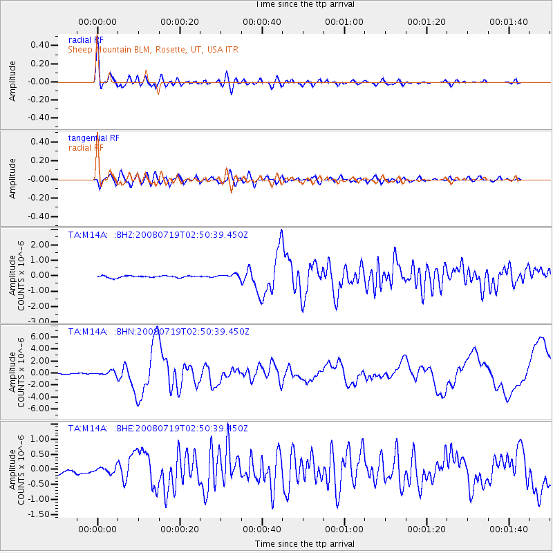
| Radial Match: |
95.256 % |
| Radial Bump: |
400 |
| Transverse Match: |
83.88396 % |
| Transverse Bump: |
400 |
| SOD ConfigId: |
2504 |
| Insert Time: |
2010-03-06 00:33:43.103 +0000 |
| GWidth: |
2.5 |
| Max Bumps: |
400 |
| Tol: |
0.001 |
|
Signal To Noise
| Channel | StoN | STA | LTA |
| TA:M14A: :BHN:20080719T02:50:39.450Z | 5.387956 | 3.7647555E-7 | 6.9873536E-8 |
| TA:M14A: :BHE:20080719T02:50:39.450Z | 1.2916323 | 1.0055079E-7 | 7.784785E-8 |
| TA:M14A: :BHZ:20080719T02:50:39.450Z | 2.0917366 | 1.275459E-7 | 6.097608E-8 |
| Arrivals |
| Ps | 2.9 SECOND |
| PpPs | 7.8 SECOND |
| PsPs/PpSs | 11 SECOND |


