You are here: Home > Network List > TA - USArray Transportable Network (new EarthScope stations) Stations List
> Station M14A Sheep Mountain BLM, Rosette, UT, USA > Earthquake Result Viewer
M14A Sheep Mountain BLM, Rosette, UT, USA - Earthquake Result Viewer
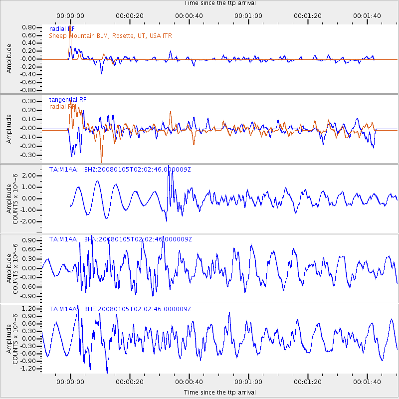
| Earthquake location: |
Guatemala |
| Earthquake latitude/longitude: |
14.1/-91.5 |
| Earthquake time(UTC): |
2008/01/05 (005) 01:56:45 GMT |
| Earthquake Depth: |
66 km |
| Earthquake Magnitude: |
5.6 MW, 5.4 MB, 5.6 MW |
| Earthquake Catalog/Contributor: |
WHDF/NEIC |
|
| Network: |
TA USArray Transportable Network (new EarthScope stations) |
| Station: |
M14A Sheep Mountain BLM, Rosette, UT, USA |
| Lat/Lon: |
41.50 N/113.35 W |
| Elevation: |
1318 m |
|
| Distance: |
33.2 deg |
| Az: |
329.309 deg |
| Baz: |
138.759 deg |
| Ray Param: |
0.078134455 |
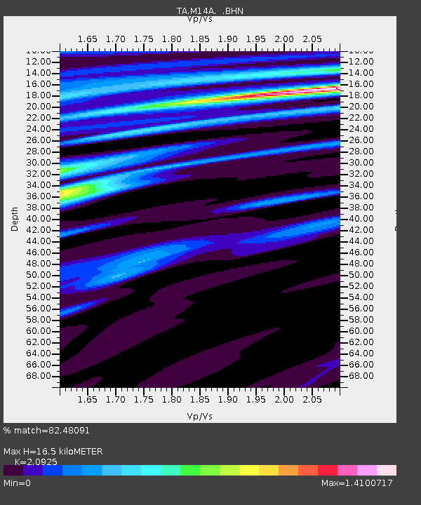
| Estimated Moho Depth: |
16.5 km |
| Estimated Crust Vp/Vs: |
2.09 |
| Assumed Crust Vp: |
6.276 km/s |
| Estimated Crust Vs: |
2.999 km/s |
| Estimated Crust Poisson's Ratio: |
0.35 |
|
| Radial Match: |
82.48091 % |
| Radial Bump: |
400 |
| Transverse Match: |
81.41458 % |
| Transverse Bump: |
400 |
| SOD ConfigId: |
2564 |
| Insert Time: |
2010-03-06 00:34:04.476 +0000 |
| GWidth: |
2.5 |
| Max Bumps: |
400 |
| Tol: |
0.001 |
|
Signal To Noise
| Channel | StoN | STA | LTA |
| TA:M14A: :BHN:20080105T02:02:46.000009Z | 1.5464396 | 2.9763075E-7 | 1.9246191E-7 |
| TA:M14A: :BHE:20080105T02:02:46.000009Z | 1.2329627 | 6.7386844E-7 | 5.46544E-7 |
| TA:M14A: :BHZ:20080105T02:02:46.000009Z | 1.4079057 | 1.2241026E-6 | 8.694493E-7 |
| Arrivals |
| Ps | 3.1 SECOND |
| PpPs | 7.6 SECOND |
| PsPs/PpSs | 11 SECOND |


