You are here: Home > Network List > TA - USArray Transportable Network (new EarthScope stations) Stations List
> Station M14A Sheep Mountain BLM, Rosette, UT, USA > Earthquake Result Viewer
M14A Sheep Mountain BLM, Rosette, UT, USA - Earthquake Result Viewer
| Earthquake location: |
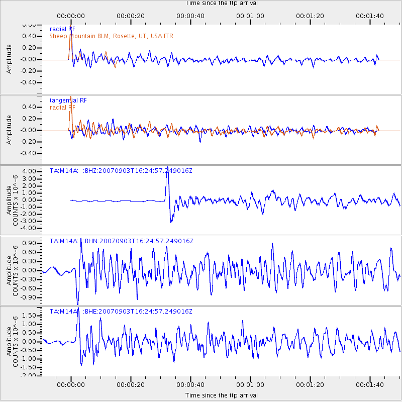
Kuril Islands |
| Earthquake latitude/longitude: |
45.8/150.1 |
| Earthquake time(UTC): |
2007/09/03 (246) 16:14:53 GMT |
| Earthquake Depth: |
94 km |
| Earthquake Magnitude: |
6.3 MB, 6.2 MW, 6.2 ME |
| Earthquake Catalog/Contributor: |
WHDF/NEIC |
|
| Network: |
TA USArray Transportable Network (new EarthScope stations) |
| Station: |
M14A Sheep Mountain BLM, Rosette, UT, USA |
| Lat/Lon: |
41.50 N/113.35 W |
| Elevation: |
1318 m |
|
| Distance: |
65.7 deg |
| Az: |
54.963 deg |
| Baz: |
310.351 deg |
| Ray Param: |
0.057863846 |
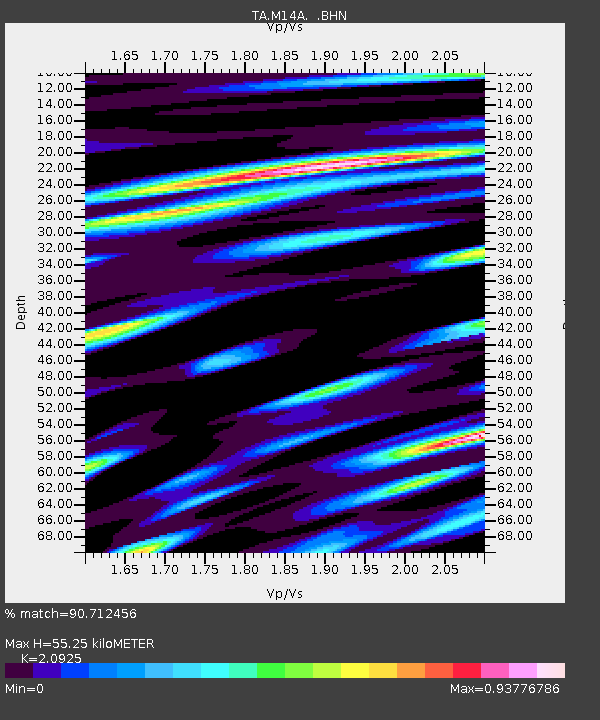
| Estimated Moho Depth: |
55.25 km |
| Estimated Crust Vp/Vs: |
2.09 |
| Assumed Crust Vp: |
6.276 km/s |
| Estimated Crust Vs: |
2.999 km/s |
| Estimated Crust Poisson's Ratio: |
0.35 |
|
| Radial Match: |
90.712456 % |
| Radial Bump: |
400 |
| Transverse Match: |
83.796715 % |
| Transverse Bump: |
400 |
| SOD ConfigId: |
2564 |
| Insert Time: |
2010-03-06 00:34:39.257 +0000 |
| GWidth: |
2.5 |
| Max Bumps: |
400 |
| Tol: |
0.001 |
|
Signal To Noise
| Channel | StoN | STA | LTA |
| TA:M14A: :BHN:20070903T16:24:57.249016Z | 6.112768 | 5.0875445E-7 | 8.322816E-8 |
| TA:M14A: :BHE:20070903T16:24:57.249016Z | 10.402444 | 8.4108405E-7 | 8.085446E-8 |
| TA:M14A: :BHZ:20070903T16:24:57.249016Z | 48.86861 | 2.089311E-6 | 4.2753637E-8 |
| Arrivals |
| Ps | 9.9 SECOND |
| PpPs | 26 SECOND |
| PsPs/PpSs | 36 SECOND |


