You are here: Home > Network List > TA - USArray Transportable Network (new EarthScope stations) Stations List
> Station M14A Sheep Mountain BLM, Rosette, UT, USA > Earthquake Result Viewer
M14A Sheep Mountain BLM, Rosette, UT, USA - Earthquake Result Viewer
| Earthquake location: |
Near Coast Of Peru |
| Earthquake latitude/longitude: |
-13.6/-76.6 |
| Earthquake time(UTC): |
2007/08/19 (231) 01:22:40 GMT |
| Earthquake Depth: |
26 km |
| Earthquake Magnitude: |
5.9 MB, 5.4 MS, 5.8 MW, 5.5 ML |
| Earthquake Catalog/Contributor: |
WHDF/NEIC |
|
| Network: |
TA USArray Transportable Network (new EarthScope stations) |
| Station: |
M14A Sheep Mountain BLM, Rosette, UT, USA |
| Lat/Lon: |
41.50 N/113.35 W |
| Elevation: |
1318 m |
|
| Distance: |
64.5 deg |
| Az: |
330.148 deg |
| Baz: |
139.89 deg |
| Ray Param: |
0.05885422 |
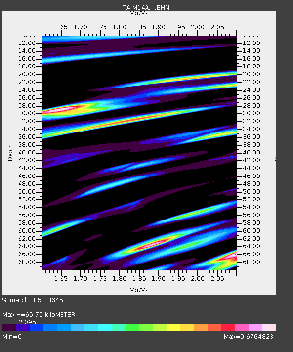
| Estimated Moho Depth: |
65.75 km |
| Estimated Crust Vp/Vs: |
2.10 |
| Assumed Crust Vp: |
6.276 km/s |
| Estimated Crust Vs: |
2.996 km/s |
| Estimated Crust Poisson's Ratio: |
0.35 |
|
| Radial Match: |
85.18645 % |
| Radial Bump: |
400 |
| Transverse Match: |
76.691 % |
| Transverse Bump: |
400 |
| SOD ConfigId: |
2564 |
| Insert Time: |
2010-03-06 00:34:43.972 +0000 |
| GWidth: |
2.5 |
| Max Bumps: |
400 |
| Tol: |
0.001 |
|

Signal To Noise
| Channel | StoN | STA | LTA |
| TA:M14A: :BHN:20070819T01:32:43.925015Z | 3.0222988 | 1.2480686E-7 | 4.1295344E-8 |
| TA:M14A: :BHE:20070819T01:32:43.925015Z | 2.1175888 | 1.5529538E-7 | 7.333595E-8 |
| TA:M14A: :BHZ:20070819T01:32:43.925015Z | 8.960899 | 4.912607E-7 | 5.4822703E-8 |
| Arrivals |
| Ps | 12 SECOND |
| PpPs | 31 SECOND |
| PsPs/PpSs | 43 SECOND |


