You are here: Home > Network List > TA - USArray Transportable Network (new EarthScope stations) Stations List
> Station M14A Sheep Mountain BLM, Rosette, UT, USA > Earthquake Result Viewer
M14A Sheep Mountain BLM, Rosette, UT, USA - Earthquake Result Viewer
| Earthquake location: |
Near West Coast Of Honshu, Japan |
| Earthquake latitude/longitude: |
37.5/138.4 |
| Earthquake time(UTC): |
2007/07/16 (197) 01:13:22 GMT |
| Earthquake Depth: |
12 km |
| Earthquake Magnitude: |
6.5 MB, 6.4 MS, 6.6 MW, 6.5 MW |
| Earthquake Catalog/Contributor: |
WHDF/NEIC |
|
| Network: |
TA USArray Transportable Network (new EarthScope stations) |
| Station: |
M14A Sheep Mountain BLM, Rosette, UT, USA |
| Lat/Lon: |
41.50 N/113.35 W |
| Elevation: |
1318 m |
|
| Distance: |
77.6 deg |
| Az: |
46.922 deg |
| Baz: |
309.371 deg |
| Ray Param: |
0.050176576 |
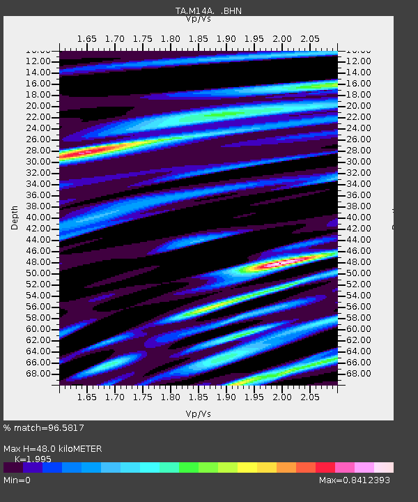
| Estimated Moho Depth: |
48.0 km |
| Estimated Crust Vp/Vs: |
2.00 |
| Assumed Crust Vp: |
6.276 km/s |
| Estimated Crust Vs: |
3.146 km/s |
| Estimated Crust Poisson's Ratio: |
0.33 |
|
| Radial Match: |
96.5817 % |
| Radial Bump: |
400 |
| Transverse Match: |
92.15463 % |
| Transverse Bump: |
400 |
| SOD ConfigId: |
2564 |
| Insert Time: |
2010-03-06 00:35:10.435 +0000 |
| GWidth: |
2.5 |
| Max Bumps: |
400 |
| Tol: |
0.001 |
|

Signal To Noise
| Channel | StoN | STA | LTA |
| TA:M14A: :BHN:20070716T01:24:47.174016Z | 14.13935 | 4.832502E-7 | 3.417768E-8 |
| TA:M14A: :BHE:20070716T01:24:47.174016Z | 18.32145 | 6.8139985E-7 | 3.7191374E-8 |
| TA:M14A: :BHZ:20070716T01:24:47.174016Z | 39.46194 | 2.2642514E-6 | 5.7378106E-8 |
| Arrivals |
| Ps | 7.8 SECOND |
| PpPs | 22 SECOND |
| PsPs/PpSs | 30 SECOND |


