You are here: Home > Network List > TA - USArray Transportable Network (new EarthScope stations) Stations List
> Station M14A Sheep Mountain BLM, Rosette, UT, USA > Earthquake Result Viewer
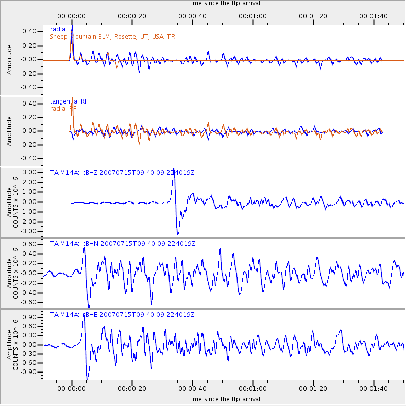
M14A Sheep Mountain BLM, Rosette, UT, USA - Earthquake Result Viewer

| Earthquake location: |
Vanuatu Islands |
| Earthquake latitude/longitude: |
-15.4/168.6 |
| Earthquake time(UTC): |
2007/07/15 (196) 09:27:34 GMT |
| Earthquake Depth: |
8.0 km |
| Earthquake Magnitude: |
6.0 MB, 5.8 MS, 6.1 MW, 6.0 MW |
| Earthquake Catalog/Contributor: |
WHDF/NEIC |
|
| Network: |
TA USArray Transportable Network (new EarthScope stations) |
| Station: |
M14A Sheep Mountain BLM, Rosette, UT, USA |
| Lat/Lon: |
41.50 N/113.35 W |
| Elevation: |
1318 m |
|
| Distance: |
91.4 deg |
| Az: |
47.314 deg |
| Baz: |
250.737 deg |
| Ray Param: |
0.041606527 |
| Estimated Moho Depth: |
45.5 km |
| Estimated Crust Vp/Vs: |
1.95 |
| Assumed Crust Vp: |
6.276 km/s |
| Estimated Crust Vs: |
3.214 km/s |
| Estimated Crust Poisson's Ratio: |
0.32 |
|
| Radial Match: |
92.72378 % |
| Radial Bump: |
400 |
| Transverse Match: |
88.70681 % |
| Transverse Bump: |
400 |
| SOD ConfigId: |
2564 |
| Insert Time: |
2010-03-06 00:35:14.603 +0000 |
| GWidth: |
2.5 |
| Max Bumps: |
400 |
| Tol: |
0.001 |
|
Signal To Noise
| Channel | StoN | STA | LTA |
| TA:M14A: :BHN:20070715T09:40:09.224019Z | 5.9599395 | 2.028103E-7 | 3.402892E-8 |
| TA:M14A: :BHE:20070715T09:40:09.224019Z | 7.274043 | 3.9059515E-7 | 5.3697114E-8 |
| TA:M14A: :BHZ:20070715T09:40:09.224019Z | 30.191492 | 1.3210741E-6 | 4.3756504E-8 |
| Arrivals |
| Ps | 7.0 SECOND |
| PpPs | 21 SECOND |
| PsPs/PpSs | 28 SECOND |


