You are here: Home > Network List > TA - USArray Transportable Network (new EarthScope stations) Stations List
> Station M14A Sheep Mountain BLM, Rosette, UT, USA > Earthquake Result Viewer
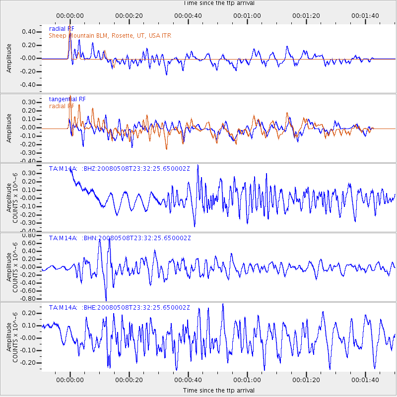
M14A Sheep Mountain BLM, Rosette, UT, USA - Earthquake Result Viewer
*The percent match for this event was below the threshold and hence no stack was calculated.
| Earthquake location: |
Near East Coast Of Honshu, Japan |
| Earthquake latitude/longitude: |
36.1/141.7 |
| Earthquake time(UTC): |
2008/05/08 (129) 23:21:06 GMT |
| Earthquake Depth: |
17 km |
| Earthquake Magnitude: |
5.6 MB, 5.2 MS, 5.6 MW, 5.5 MW |
| Earthquake Catalog/Contributor: |
WHDF/NEIC |
|
| Network: |
TA USArray Transportable Network (new EarthScope stations) |
| Station: |
M14A Sheep Mountain BLM, Rosette, UT, USA |
| Lat/Lon: |
41.50 N/113.35 W |
| Elevation: |
1318 m |
|
| Distance: |
76.7 deg |
| Az: |
48.216 deg |
| Baz: |
306.496 deg |
| Ray Param: |
$rayparam |
*The percent match for this event was below the threshold and hence was not used in the summary stack. |
|
| Radial Match: |
36.58862 % |
| Radial Bump: |
400 |
| Transverse Match: |
47.67197 % |
| Transverse Bump: |
400 |
| SOD ConfigId: |
2504 |
| Insert Time: |
2010-03-06 00:36:13.410 +0000 |
| GWidth: |
2.5 |
| Max Bumps: |
400 |
| Tol: |
0.001 |
|
Signal To Noise
| Channel | StoN | STA | LTA |
| TA:M14A: :BHN:20080508T23:32:25.650002Z | 2.2022712 | 1.5051455E-7 | 6.8345145E-8 |
| TA:M14A: :BHE:20080508T23:32:25.650002Z | 0.4381227 | 8.08689E-8 | 1.8458049E-7 |
| TA:M14A: :BHZ:20080508T23:32:25.650002Z | 0.76985025 | 9.048154E-8 | 1.1753135E-7 |
| Arrivals |
| Ps | |
| PpPs | |
| PsPs/PpSs | |


