You are here: Home > Network List > GT - Global Telemetered Seismograph Network (USAF/USGS) Stations List
> Station LPAZ La Paz , Bolivia > Earthquake Result Viewer
LPAZ La Paz , Bolivia - Earthquake Result Viewer
| Earthquake location: |
Bouvet Island Region |
| Earthquake latitude/longitude: |
-54.2/-1.5 |
| Earthquake time(UTC): |
2015/12/23 (357) 16:55:10 GMT |
| Earthquake Depth: |
15 km |
| Earthquake Magnitude: |
5.5 MB |
| Earthquake Catalog/Contributor: |
NEIC PDE/NEIC COMCAT |
|
| Network: |
GT Global Telemetered Seismograph Network (USAF/USGS) |
| Station: |
LPAZ La Paz , Bolivia |
| Lat/Lon: |
16.17 S/68.08 W |
| Elevation: |
4817 m |
|
| Distance: |
63.4 deg |
| Az: |
279.45 deg |
| Baz: |
142.939 deg |
| Ray Param: |
0.059616987 |
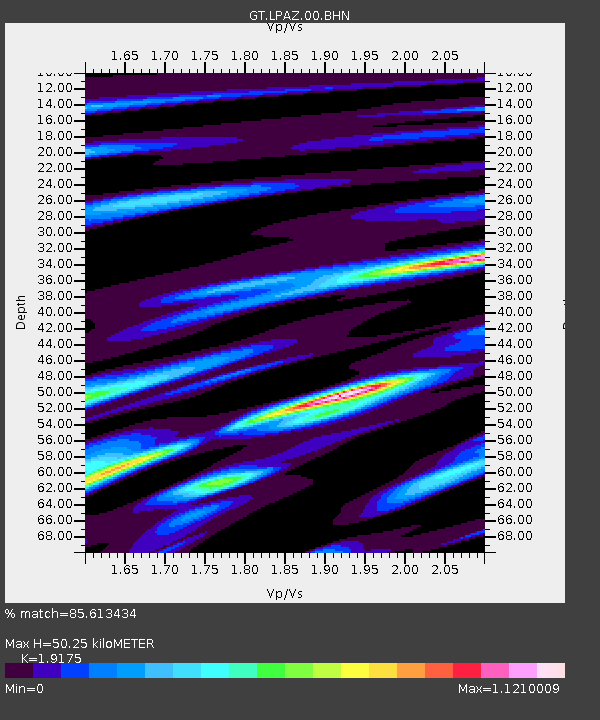
| Estimated Moho Depth: |
50.25 km |
| Estimated Crust Vp/Vs: |
1.92 |
| Assumed Crust Vp: |
6.454 km/s |
| Estimated Crust Vs: |
3.366 km/s |
| Estimated Crust Poisson's Ratio: |
0.31 |
|
| Radial Match: |
85.613434 % |
| Radial Bump: |
331 |
| Transverse Match: |
74.68864 % |
| Transverse Bump: |
400 |
| SOD ConfigId: |
1259291 |
| Insert Time: |
2016-01-06 17:03:39.353 +0000 |
| GWidth: |
2.5 |
| Max Bumps: |
400 |
| Tol: |
0.001 |
|

Signal To Noise
| Channel | StoN | STA | LTA |
| GT:LPAZ:00:BHZ:20151223T17:05:07.69999Z | 2.7824185 | 2.886505E-7 | 1.03740874E-7 |
| GT:LPAZ:00:BHN:20151223T17:05:07.69999Z | 1.815371 | 8.518696E-8 | 4.6925376E-8 |
| GT:LPAZ:00:BHE:20151223T17:05:07.69999Z | 1.7661498 | 1.494987E-7 | 8.464667E-8 |
| Arrivals |
| Ps | 7.4 SECOND |
| PpPs | 22 SECOND |
| PsPs/PpSs | 29 SECOND |


