You are here: Home > Network List > AZ - ANZA Regional Network Stations List
> Station SMER AZ.SMER > Earthquake Result Viewer
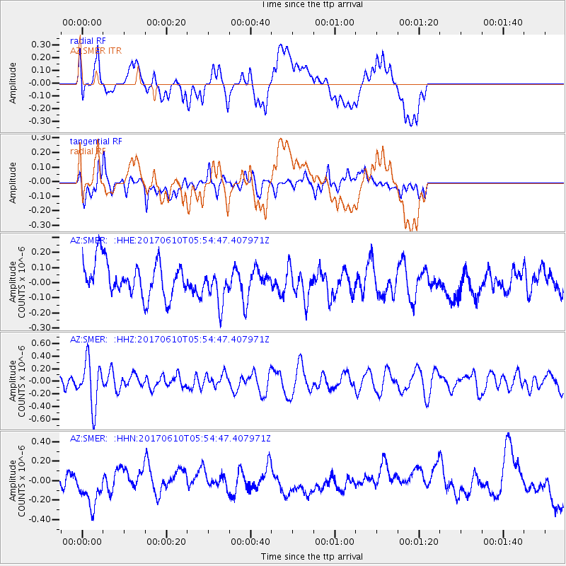
SMER AZ.SMER - Earthquake Result Viewer
*The percent match for this event was below the threshold and hence no stack was calculated.
| Earthquake location: |
Pacific-Antarctic Ridge |
| Earthquake latitude/longitude: |
-54.4/-146.7 |
| Earthquake time(UTC): |
2017/06/10 (161) 05:42:14 GMT |
| Earthquake Depth: |
10 km |
| Earthquake Magnitude: |
5.6 mb |
| Earthquake Catalog/Contributor: |
NEIC PDE/us |
|
| Network: |
AZ ANZA Regional Network |
| Station: |
SMER AZ.SMER |
| Lat/Lon: |
33.46 N/117.17 W |
| Elevation: |
355 m |
|
| Distance: |
91.1 deg |
| Az: |
24.316 deg |
| Baz: |
196.756 deg |
| Ray Param: |
$rayparam |
*The percent match for this event was below the threshold and hence was not used in the summary stack. |
|
| Radial Match: |
37.77084 % |
| Radial Bump: |
400 |
| Transverse Match: |
51.258068 % |
| Transverse Bump: |
400 |
| SOD ConfigId: |
13570011 |
| Insert Time: |
2019-04-28 04:12:21.876 +0000 |
| GWidth: |
2.5 |
| Max Bumps: |
400 |
| Tol: |
0.001 |
|
Signal To Noise
| Channel | StoN | STA | LTA |
| AZ:SMER: :HHZ:20170610T05:54:47.407971Z | 4.7320824 | 3.6662018E-7 | 7.747545E-8 |
| AZ:SMER: :HHN:20170610T05:54:47.407971Z | 2.0290978 | 2.0731754E-7 | 1.0217227E-7 |
| AZ:SMER: :HHE:20170610T05:54:47.407971Z | 1.0696288 | 1.2057889E-7 | 1.12729666E-7 |
| Arrivals |
| Ps | |
| PpPs | |
| PsPs/PpSs | |


