You are here: Home > Network List > CI - Caltech Regional Seismic Network Stations List
> Station MPM Manuel Prospect Mine, California, USA > Earthquake Result Viewer
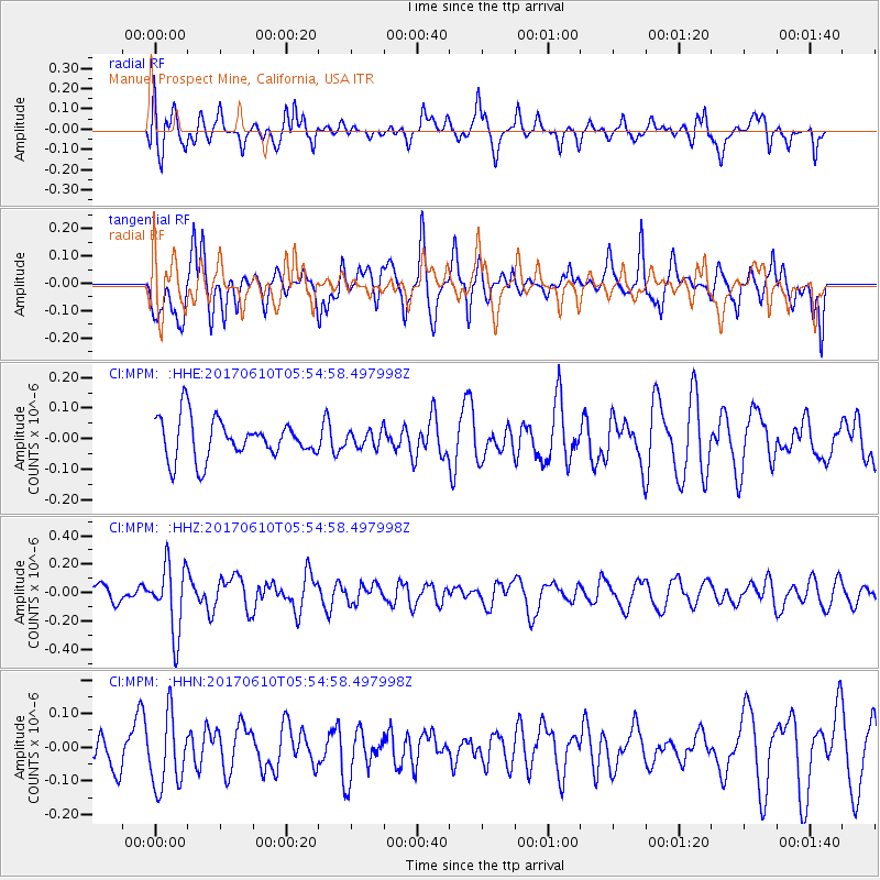
MPM Manuel Prospect Mine, California, USA - Earthquake Result Viewer
*The percent match for this event was below the threshold and hence no stack was calculated.
| Earthquake location: |
Pacific-Antarctic Ridge |
| Earthquake latitude/longitude: |
-54.4/-146.7 |
| Earthquake time(UTC): |
2017/06/10 (161) 05:42:14 GMT |
| Earthquake Depth: |
10 km |
| Earthquake Magnitude: |
5.6 mb |
| Earthquake Catalog/Contributor: |
NEIC PDE/us |
|
| Network: |
CI Caltech Regional Seismic Network |
| Station: |
MPM Manuel Prospect Mine, California, USA |
| Lat/Lon: |
36.06 N/117.49 W |
| Elevation: |
185 m |
|
| Distance: |
93.5 deg |
| Az: |
23.32 deg |
| Baz: |
196.615 deg |
| Ray Param: |
$rayparam |
*The percent match for this event was below the threshold and hence was not used in the summary stack. |
|
| Radial Match: |
62.4303 % |
| Radial Bump: |
400 |
| Transverse Match: |
58.012344 % |
| Transverse Bump: |
400 |
| SOD ConfigId: |
13570011 |
| Insert Time: |
2019-04-28 04:13:13.558 +0000 |
| GWidth: |
2.5 |
| Max Bumps: |
400 |
| Tol: |
0.001 |
|
Signal To Noise
| Channel | StoN | STA | LTA |
| CI:MPM: :HHZ:20170610T05:54:58.497998Z | 2.6199017 | 2.373714E-7 | 9.0603166E-8 |
| CI:MPM: :HHN:20170610T05:54:58.497998Z | 1.8954718 | 1.07831504E-7 | 5.6889004E-8 |
| CI:MPM: :HHE:20170610T05:54:58.497998Z | 0.46259752 | 2.9825195E-8 | 6.447332E-8 |
| Arrivals |
| Ps | |
| PpPs | |
| PsPs/PpSs | |


