You are here: Home > Network List > CI - Caltech Regional Seismic Network Stations List
> Station SWS Sam W. Stewart, Westmorland, CA, USA > Earthquake Result Viewer
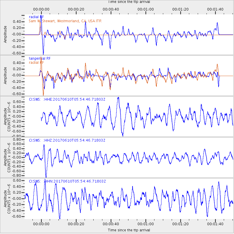
SWS Sam W. Stewart, Westmorland, CA, USA - Earthquake Result Viewer
*The percent match for this event was below the threshold and hence no stack was calculated.
| Earthquake location: |
Pacific-Antarctic Ridge |
| Earthquake latitude/longitude: |
-54.4/-146.7 |
| Earthquake time(UTC): |
2017/06/10 (161) 05:42:14 GMT |
| Earthquake Depth: |
10 km |
| Earthquake Magnitude: |
5.6 mb |
| Earthquake Catalog/Contributor: |
NEIC PDE/us |
|
| Network: |
CI Caltech Regional Seismic Network |
| Station: |
SWS Sam W. Stewart, Westmorland, CA, USA |
| Lat/Lon: |
32.94 N/115.80 W |
| Elevation: |
140 m |
|
| Distance: |
90.9 deg |
| Az: |
25.57 deg |
| Baz: |
197.483 deg |
| Ray Param: |
$rayparam |
*The percent match for this event was below the threshold and hence was not used in the summary stack. |
|
| Radial Match: |
72.265854 % |
| Radial Bump: |
400 |
| Transverse Match: |
57.843666 % |
| Transverse Bump: |
400 |
| SOD ConfigId: |
13570011 |
| Insert Time: |
2019-04-28 04:13:24.626 +0000 |
| GWidth: |
2.5 |
| Max Bumps: |
400 |
| Tol: |
0.001 |
|
Signal To Noise
| Channel | StoN | STA | LTA |
| CI:SWS: :HHZ:20170610T05:54:46.71803Z | 2.3656886 | 3.7985242E-7 | 1.605674E-7 |
| CI:SWS: :HHN:20170610T05:54:46.71803Z | 2.0013974 | 2.9600136E-7 | 1.4789735E-7 |
| CI:SWS: :HHE:20170610T05:54:46.71803Z | 1.6944194 | 3.2611155E-7 | 1.9246211E-7 |
| Arrivals |
| Ps | |
| PpPs | |
| PsPs/PpSs | |


