You are here: Home > Network List > TA - USArray Transportable Network (new EarthScope stations) Stations List
> Station 121A Cookes Peak, Deming, NM, USA > Earthquake Result Viewer
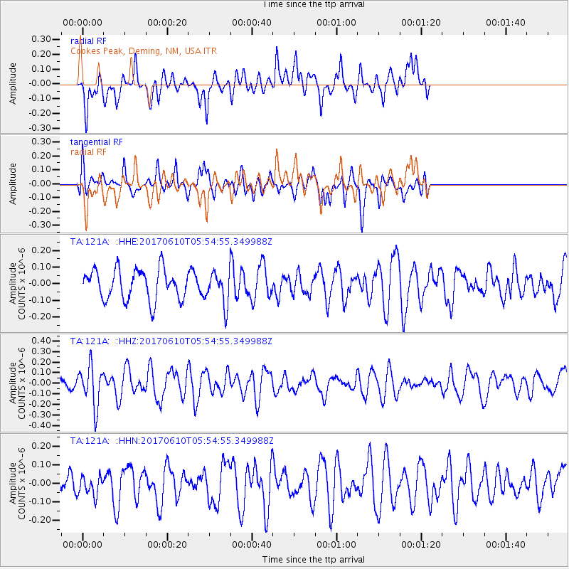
121A Cookes Peak, Deming, NM, USA - Earthquake Result Viewer
*The percent match for this event was below the threshold and hence no stack was calculated.
| Earthquake location: |
Pacific-Antarctic Ridge |
| Earthquake latitude/longitude: |
-54.4/-146.7 |
| Earthquake time(UTC): |
2017/06/10 (161) 05:42:14 GMT |
| Earthquake Depth: |
10 km |
| Earthquake Magnitude: |
5.6 mb |
| Earthquake Catalog/Contributor: |
NEIC PDE/us |
|
| Network: |
TA USArray Transportable Network (new EarthScope stations) |
| Station: |
121A Cookes Peak, Deming, NM, USA |
| Lat/Lon: |
32.53 N/107.79 W |
| Elevation: |
1652 m |
|
| Distance: |
92.8 deg |
| Az: |
32.07 deg |
| Baz: |
201.587 deg |
| Ray Param: |
$rayparam |
*The percent match for this event was below the threshold and hence was not used in the summary stack. |
|
| Radial Match: |
59.142155 % |
| Radial Bump: |
400 |
| Transverse Match: |
44.6628 % |
| Transverse Bump: |
337 |
| SOD ConfigId: |
13570011 |
| Insert Time: |
2019-04-28 04:15:17.635 +0000 |
| GWidth: |
2.5 |
| Max Bumps: |
400 |
| Tol: |
0.001 |
|
Signal To Noise
| Channel | StoN | STA | LTA |
| TA:121A: :HHZ:20170610T05:54:55.349988Z | 1.9592316 | 1.9411812E-7 | 9.90787E-8 |
| TA:121A: :HHN:20170610T05:54:55.349988Z | 0.61753577 | 4.9307125E-8 | 7.984497E-8 |
| TA:121A: :HHE:20170610T05:54:55.349988Z | 1.2501321 | 1.1505693E-7 | 9.203582E-8 |
| Arrivals |
| Ps | |
| PpPs | |
| PsPs/PpSs | |


