You are here: Home > Network List > TA - USArray Transportable Network (new EarthScope stations) Stations List
> Station TPFO Pinon Flats, CA, USA > Earthquake Result Viewer
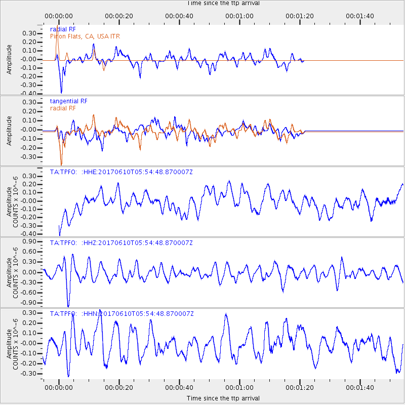
TPFO Pinon Flats, CA, USA - Earthquake Result Viewer
*The percent match for this event was below the threshold and hence no stack was calculated.
| Earthquake location: |
Pacific-Antarctic Ridge |
| Earthquake latitude/longitude: |
-54.4/-146.7 |
| Earthquake time(UTC): |
2017/06/10 (161) 05:42:14 GMT |
| Earthquake Depth: |
10 km |
| Earthquake Magnitude: |
5.6 mb |
| Earthquake Catalog/Contributor: |
NEIC PDE/us |
|
| Network: |
TA USArray Transportable Network (new EarthScope stations) |
| Station: |
TPFO Pinon Flats, CA, USA |
| Lat/Lon: |
33.61 N/116.45 W |
| Elevation: |
1275 m |
|
| Distance: |
91.4 deg |
| Az: |
24.846 deg |
| Baz: |
197.138 deg |
| Ray Param: |
$rayparam |
*The percent match for this event was below the threshold and hence was not used in the summary stack. |
|
| Radial Match: |
49.927025 % |
| Radial Bump: |
374 |
| Transverse Match: |
29.00641 % |
| Transverse Bump: |
400 |
| SOD ConfigId: |
13570011 |
| Insert Time: |
2019-04-28 04:15:22.820 +0000 |
| GWidth: |
2.5 |
| Max Bumps: |
400 |
| Tol: |
0.001 |
|
Signal To Noise
| Channel | StoN | STA | LTA |
| TA:TPFO: :HHZ:20170610T05:54:48.870007Z | 5.220244 | 4.4892292E-7 | 8.599654E-8 |
| TA:TPFO: :HHN:20170610T05:54:48.870007Z | 1.9123476 | 1.6372925E-7 | 8.56169E-8 |
| TA:TPFO: :HHE:20170610T05:54:48.870007Z | 0.50437397 | 6.073626E-8 | 1.2041912E-7 |
| Arrivals |
| Ps | |
| PpPs | |
| PsPs/PpSs | |


