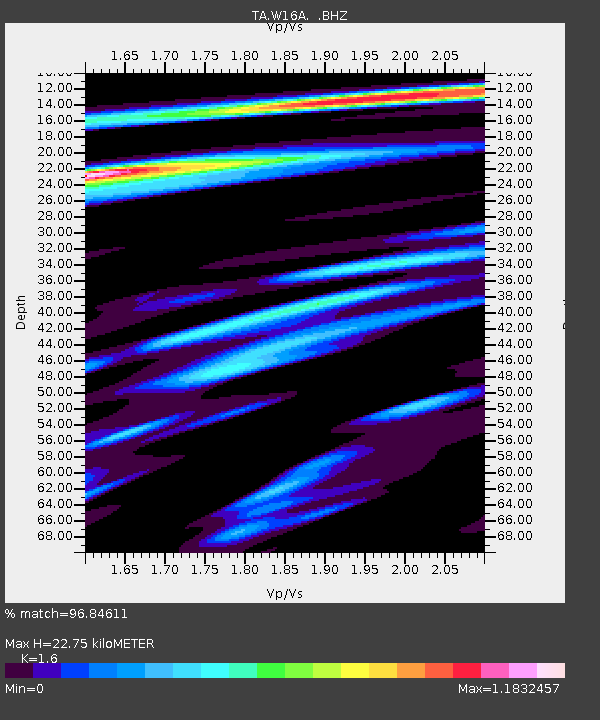
W16A Flagstaff, AZ, USA - Earthquake Result Viewer
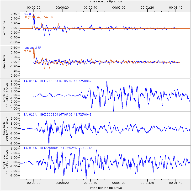
Earthquake location: Andreanof Islands, Aleutian Is.
Earthquake latitude/longitude: 51.9/-179.2
Earthquake time(UTC): 2008/04/16 (107) 05:54:19 GMT
Earthquake Depth: 13 km
Earthquake Magnitude: 6.1 MB, 6.5 MS, 6.6 MW, 6.6 MW
Earthquake Catalog/Contributor: WHDF/NEIC
Network: TA USArray Transportable Network (new EarthScope stations)
Station: W16A Flagstaff, AZ, USA
Lat/Lon: 35.10 N/111.53 W
Elevation: 2192 m
Distance: 50.0 deg
Az: 81.75 deg
Baz: 311.57 deg
Ray Param: 0.06832422
Estimated Moho Depth: 22.75 km
Estimated Crust Vp/Vs: 1.60
Assumed Crust Vp: 6.207 km/s
Estimated Crust Vs: 3.879 km/s
Estimated Crust Poisson's Ratio: 0.18
Radial Match: 96.84611 %
Radial Bump: 400
Transverse Match: 76.563034 %
Transverse Bump: 400
SOD ConfigId: 2504
Insert Time: 2010-03-06 00:37:04.997 +0000
GWidth: 2.5
Max Bumps: 400
Tol: 0.001

Signal To Noise

ChannelStoNSTALTA
TA:W16A: :BHZ:20080416T06:02:42.725004Z2.45598481.0069111E-64.0998265E-7
TA:W16A: :BHN:20080416T06:02:42.725004Z0.826879563.1552534E-73.815856E-7
TA:W16A: :BHE:20080416T06:02:42.725004Z1.2815693.6707033E-72.864226E-7
Arrivals
Ps2.3 SECOND
PpPs9.0 SECOND
PsPs/PpSs11 SECOND