You are here: Home > Network List > TA - USArray Transportable Network (new EarthScope stations) Stations List
> Station W16A Flagstaff, AZ, USA > Earthquake Result Viewer
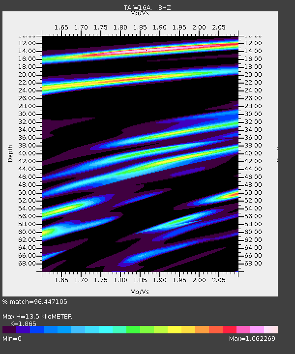
W16A Flagstaff, AZ, USA - Earthquake Result Viewer
| Earthquake location: |
Sea Of Okhotsk |
| Earthquake latitude/longitude: |
53.9/152.9 |
| Earthquake time(UTC): |
2008/07/05 (187) 02:12:04 GMT |
| Earthquake Depth: |
633 km |
| Earthquake Magnitude: |
6.8 MB, 7.7 MW, 7.7 MW |
| Earthquake Catalog/Contributor: |
WHDF/NEIC |
|
| Network: |
TA USArray Transportable Network (new EarthScope stations) |
| Station: |
W16A Flagstaff, AZ, USA |
| Lat/Lon: |
35.10 N/111.53 W |
| Elevation: |
2192 m |
|
| Distance: |
65.5 deg |
| Az: |
63.712 deg |
| Baz: |
319.66 deg |
| Ray Param: |
0.055815205 |
| Estimated Moho Depth: |
13.5 km |
| Estimated Crust Vp/Vs: |
1.87 |
| Assumed Crust Vp: |
6.207 km/s |
| Estimated Crust Vs: |
3.328 km/s |
| Estimated Crust Poisson's Ratio: |
0.30 |
|
| Radial Match: |
96.447105 % |
| Radial Bump: |
400 |
| Transverse Match: |
86.35073 % |
| Transverse Bump: |
400 |
| SOD ConfigId: |
2504 |
| Insert Time: |
2010-03-06 00:37:26.207 +0000 |
| GWidth: |
2.5 |
| Max Bumps: |
400 |
| Tol: |
0.001 |
|

Signal To Noise
| Channel | StoN | STA | LTA |
| TA:W16A: :BHZ:20080705T02:21:16.550007Z | 32.921135 | 3.008292E-6 | 9.1378745E-8 |
| TA:W16A: :BHN:20080705T02:21:16.550007Z | 15.422656 | 1.0452729E-6 | 6.7775154E-8 |
| TA:W16A: :BHE:20080705T02:21:16.550007Z | 13.01901 | 8.261136E-7 | 6.345441E-8 |
| Arrivals |
| Ps | 1.9 SECOND |
| PpPs | 6.0 SECOND |
| PsPs/PpSs | 8.0 SECOND |


