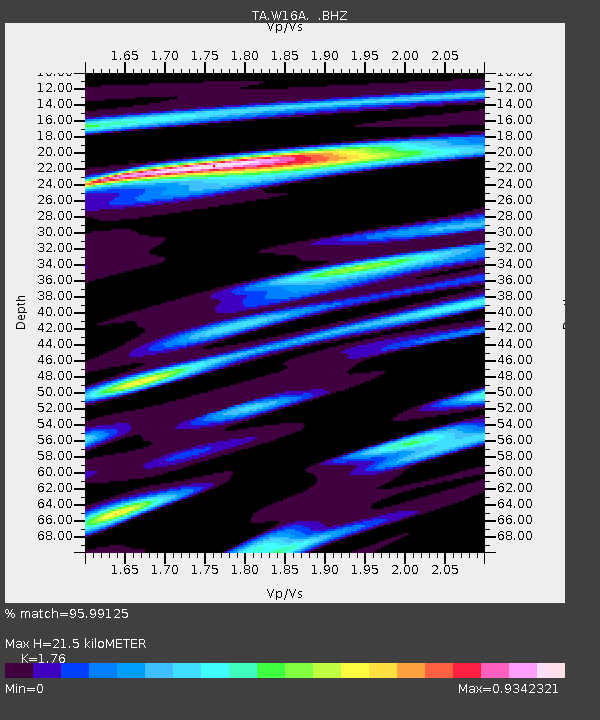
W16A Flagstaff, AZ, USA - Earthquake Result Viewer
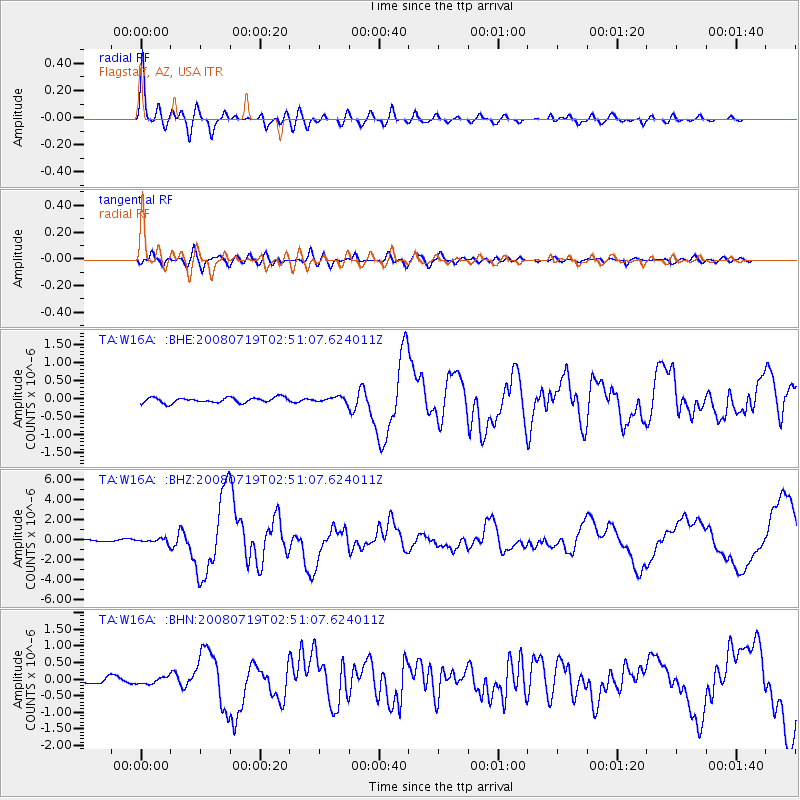
Earthquake location: Off East Coast Of Honshu, Japan
Earthquake latitude/longitude: 37.6/142.2
Earthquake time(UTC): 2008/07/19 (201) 02:39:28 GMT
Earthquake Depth: 22 km
Earthquake Magnitude: 6.2 MB, 7.0 MS, 7.0 MW, 6.9 MW
Earthquake Catalog/Contributor: WHDF/NEIC
Network: TA USArray Transportable Network (new EarthScope stations)
Station: W16A Flagstaff, AZ, USA
Lat/Lon: 35.10 N/111.53 W
Elevation: 2192 m
Distance: 80.5 deg
Az: 52.955 deg
Baz: 309.322 deg
Ray Param: 0.048207898
Estimated Moho Depth: 21.5 km
Estimated Crust Vp/Vs: 1.76
Assumed Crust Vp: 6.207 km/s
Estimated Crust Vs: 3.527 km/s
Estimated Crust Poisson's Ratio: 0.26
Radial Match: 95.99125 %
Radial Bump: 393
Transverse Match: 80.017296 %
Transverse Bump: 400
SOD ConfigId: 2504
Insert Time: 2010-03-06 00:37:28.338 +0000
GWidth: 2.5
Max Bumps: 400
Tol: 0.001

Signal To Noise

ChannelStoNSTALTA
TA:W16A: :BHZ:20080719T02:51:07.624011Z2.45607882.3058176E-79.3882065E-8
TA:W16A: :BHN:20080719T02:51:07.624011Z1.14378421.0389971E-79.083857E-8
TA:W16A: :BHE:20080719T02:51:07.624011Z0.98490787.2280024E-87.33876E-8
Arrivals
Ps2.7 SECOND
PpPs9.3 SECOND
PsPs/PpSs12 SECOND