You are here: Home > Network List > TA - USArray Transportable Network (new EarthScope stations) Stations List
> Station W16A Flagstaff, AZ, USA > Earthquake Result Viewer
W16A Flagstaff, AZ, USA - Earthquake Result Viewer
| Earthquake location: |
East Of Kuril Islands |
| Earthquake latitude/longitude: |
46.0/154.2 |
| Earthquake time(UTC): |
2007/10/25 (298) 13:50:02 GMT |
| Earthquake Depth: |
10 km |
| Earthquake Magnitude: |
6.0 MB, 5.7 MS, 6.1 MW, 5.9 MW |
| Earthquake Catalog/Contributor: |
WHDF/NEIC |
|
| Network: |
TA USArray Transportable Network (new EarthScope stations) |
| Station: |
W16A Flagstaff, AZ, USA |
| Lat/Lon: |
35.10 N/111.53 W |
| Elevation: |
2192 m |
|
| Distance: |
68.4 deg |
| Az: |
61.589 deg |
| Baz: |
311.621 deg |
| Ray Param: |
0.05633139 |
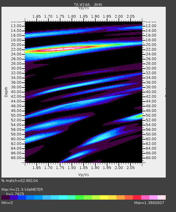
| Estimated Moho Depth: |
21.5 km |
| Estimated Crust Vp/Vs: |
1.76 |
| Assumed Crust Vp: |
6.207 km/s |
| Estimated Crust Vs: |
3.522 km/s |
| Estimated Crust Poisson's Ratio: |
0.26 |
|
| Radial Match: |
82.98104 % |
| Radial Bump: |
400 |
| Transverse Match: |
66.453445 % |
| Transverse Bump: |
400 |
| SOD ConfigId: |
2564 |
| Insert Time: |
2010-03-06 00:38:16.692 +0000 |
| GWidth: |
2.5 |
| Max Bumps: |
400 |
| Tol: |
0.001 |
|

Signal To Noise
| Channel | StoN | STA | LTA |
| TA:W16A: :BHN:20071025T14:00:33.150029Z | 1.1237153 | 1.0433295E-7 | 9.284643E-8 |
| TA:W16A: :BHE:20071025T14:00:33.150029Z | 0.6465077 | 1.00657054E-7 | 1.5569351E-7 |
| TA:W16A: :BHZ:20071025T14:00:33.150029Z | 5.2612076 | 3.7972148E-7 | 7.217382E-8 |
| Arrivals |
| Ps | 2.7 SECOND |
| PpPs | 9.2 SECOND |
| PsPs/PpSs | 12 SECOND |


