You are here: Home > Network List > TA - USArray Transportable Network (new EarthScope stations) Stations List
> Station P17K Kvichak River, AK, USA > Earthquake Result Viewer
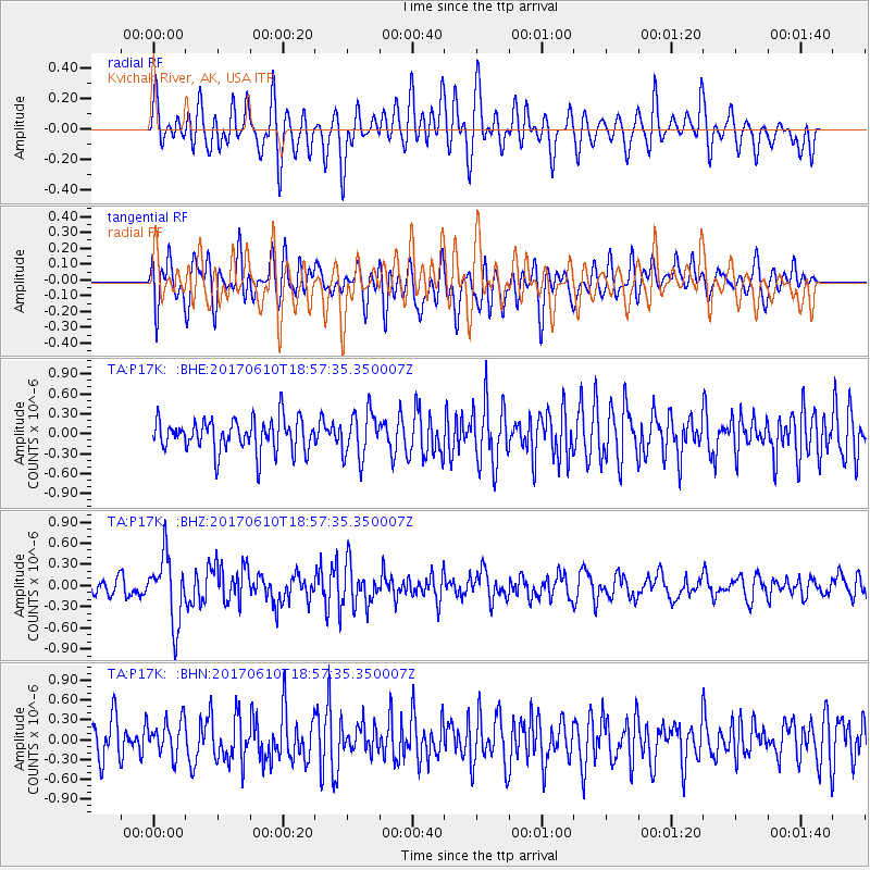
P17K Kvichak River, AK, USA - Earthquake Result Viewer
*The percent match for this event was below the threshold and hence no stack was calculated.
| Earthquake location: |
Near Coast Of Chiapas, Mexico |
| Earthquake latitude/longitude: |
14.3/-93.0 |
| Earthquake time(UTC): |
2017/06/10 (161) 18:47:31 GMT |
| Earthquake Depth: |
10 km |
| Earthquake Magnitude: |
5.5 Mww |
| Earthquake Catalog/Contributor: |
NEIC PDE/us |
|
| Network: |
TA USArray Transportable Network (new EarthScope stations) |
| Station: |
P17K Kvichak River, AK, USA |
| Lat/Lon: |
59.20 N/156.44 W |
| Elevation: |
91 m |
|
| Distance: |
64.3 deg |
| Az: |
329.278 deg |
| Baz: |
105.802 deg |
| Ray Param: |
$rayparam |
*The percent match for this event was below the threshold and hence was not used in the summary stack. |
|
| Radial Match: |
58.25535 % |
| Radial Bump: |
400 |
| Transverse Match: |
45.295906 % |
| Transverse Bump: |
400 |
| SOD ConfigId: |
13570011 |
| Insert Time: |
2019-04-28 04:21:41.537 +0000 |
| GWidth: |
2.5 |
| Max Bumps: |
400 |
| Tol: |
0.001 |
|
Signal To Noise
| Channel | StoN | STA | LTA |
| TA:P17K: :BHZ:20170610T18:57:35.350007Z | 3.9325712 | 4.7740843E-7 | 1.2139856E-7 |
| TA:P17K: :BHN:20170610T18:57:35.350007Z | 1.0704814 | 2.6457784E-7 | 2.4715783E-7 |
| TA:P17K: :BHE:20170610T18:57:35.350007Z | 1.4120879 | 3.439104E-7 | 2.4354742E-7 |
| Arrivals |
| Ps | |
| PpPs | |
| PsPs/PpSs | |


