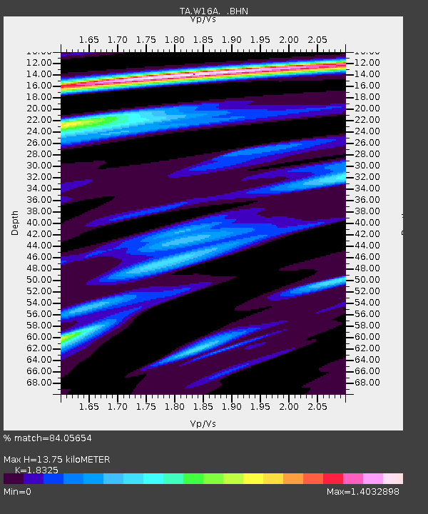
W16A Flagstaff, AZ, USA - Earthquake Result Viewer

Earthquake location: Andreanof Islands, Aleutian Is.
Earthquake latitude/longitude: 50.3/-177.5
Earthquake time(UTC): 2007/08/15 (227) 20:22:11 GMT
Earthquake Depth: 9.0 km
Earthquake Magnitude: 6.3 MB, 6.2 MS, 6.4 MW, 5.9 ML
Earthquake Catalog/Contributor: WHDF/NEIC
Network: TA USArray Transportable Network (new EarthScope stations)
Station: W16A Flagstaff, AZ, USA
Lat/Lon: 35.10 N/111.53 W
Elevation: 2192 m
Distance: 49.2 deg
Az: 81.569 deg
Baz: 309.352 deg
Ray Param: 0.06883183
Estimated Moho Depth: 13.75 km
Estimated Crust Vp/Vs: 1.83
Assumed Crust Vp: 6.207 km/s
Estimated Crust Vs: 3.387 km/s
Estimated Crust Poisson's Ratio: 0.29
Radial Match: 84.05654 %
Radial Bump: 314
Transverse Match: 50.948284 %
Transverse Bump: 400
SOD ConfigId: 2564
Insert Time: 2010-03-06 00:38:48.878 +0000
GWidth: 2.5
Max Bumps: 400
Tol: 0.001

Signal To Noise

ChannelStoNSTALTA
TA:W16A: :BHN:20070815T20:30:28.850011Z1.99573451.4681165E-67.356271E-7
TA:W16A: :BHE:20070815T20:30:28.850011Z1.44939791.2237284E-68.443012E-7
TA:W16A: :BHZ:20070815T20:30:28.850011Z2.59309432.1918822E-68.4527665E-7
Arrivals
Ps1.9 SECOND
PpPs6.0 SECOND
PsPs/PpSs7.9 SECOND