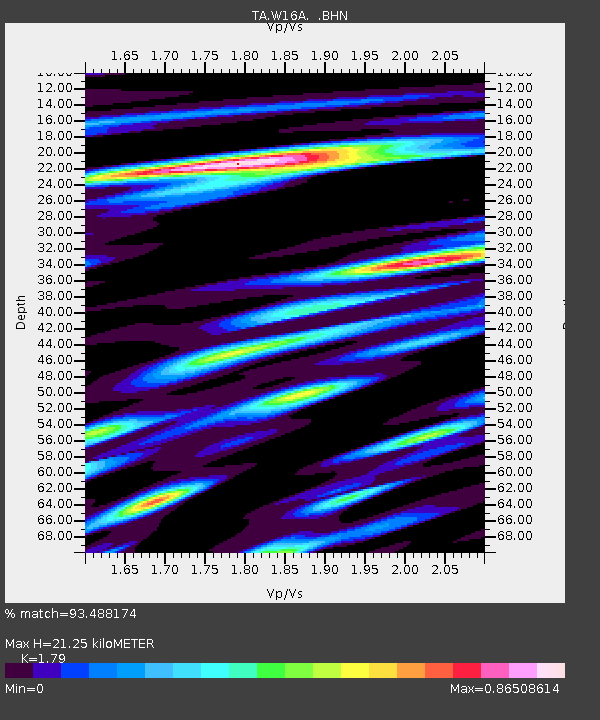
W16A Flagstaff, AZ, USA - Earthquake Result Viewer

Earthquake location: Near West Coast Of Honshu, Japan
Earthquake latitude/longitude: 37.5/138.4
Earthquake time(UTC): 2007/07/16 (197) 01:13:22 GMT
Earthquake Depth: 12 km
Earthquake Magnitude: 6.5 MB, 6.4 MS, 6.6 MW, 6.5 MW
Earthquake Catalog/Contributor: WHDF/NEIC
Network: TA USArray Transportable Network (new EarthScope stations)
Station: W16A Flagstaff, AZ, USA
Lat/Lon: 35.10 N/111.53 W
Elevation: 2192 m
Distance: 82.9 deg
Az: 50.936 deg
Baz: 311.174 deg
Ray Param: 0.04658034
Estimated Moho Depth: 21.25 km
Estimated Crust Vp/Vs: 1.79
Assumed Crust Vp: 6.207 km/s
Estimated Crust Vs: 3.467 km/s
Estimated Crust Poisson's Ratio: 0.27
Radial Match: 93.488174 %
Radial Bump: 400
Transverse Match: 90.70363 %
Transverse Bump: 400
SOD ConfigId: 2564
Insert Time: 2010-03-06 00:39:05.227 +0000
GWidth: 2.5
Max Bumps: 400
Tol: 0.001

Signal To Noise

ChannelStoNSTALTA
TA:W16A: :BHN:20070716T01:25:15.224004Z6.34110163.1785487E-75.0126125E-8
TA:W16A: :BHE:20070716T01:25:15.224004Z8.0249833.5957487E-74.480693E-8
TA:W16A: :BHZ:20070716T01:25:15.224004Z68.680141.8461699E-62.6880697E-8
Arrivals
Ps2.8 SECOND
PpPs9.3 SECOND
PsPs/PpSs12 SECOND