You are here: Home > Network List > G - GEOSCOPE Stations List
> Station RER Riviere de l'Est, La Reunion (Indian Ocean) > Earthquake Result Viewer
RER Riviere de l'Est, La Reunion (Indian Ocean) - Earthquake Result Viewer

| Earthquake location: |
Afghanistan-Tajikistan Bord Reg. |
| Earthquake latitude/longitude: |
36.5/71.1 |
| Earthquake time(UTC): |
2015/12/25 (359) 19:14:48 GMT |
| Earthquake Depth: |
204 km |
| Earthquake Magnitude: |
6.2 MO |
| Earthquake Catalog/Contributor: |
NEIC PDE/NEIC ALERT |
|
| Network: |
G GEOSCOPE |
| Station: |
RER Riviere de l'Est, La Reunion (Indian Ocean) |
| Lat/Lon: |
21.16 S/55.75 E |
| Elevation: |
834 m |
|
| Distance: |
59.2 deg |
| Az: |
196.765 deg |
| Baz: |
14.416 deg |
| Ray Param: |
0.061698508 |
| Estimated Moho Depth: |
10.0 km |
| Estimated Crust Vp/Vs: |
2.03 |
| Assumed Crust Vp: |
4.73 km/s |
| Estimated Crust Vs: |
2.327 km/s |
| Estimated Crust Poisson's Ratio: |
0.34 |
|
| Radial Match: |
90.889595 % |
| Radial Bump: |
400 |
| Transverse Match: |
68.14605 % |
| Transverse Bump: |
400 |
| SOD ConfigId: |
1259291 |
| Insert Time: |
2016-01-08 19:45:44.319 +0000 |
| GWidth: |
2.5 |
| Max Bumps: |
400 |
| Tol: |
0.001 |
|
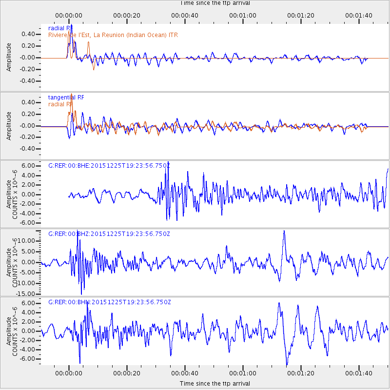
Signal To Noise
| Channel | StoN | STA | LTA |
| G:RER:00:BHZ:20151225T19:23:56.750Z | 7.3311186 | 6.004604E-6 | 8.1905705E-7 |
| G:RER:00:BHN:20151225T19:23:56.750Z | 2.6772995 | 1.9104666E-6 | 7.135797E-7 |
| G:RER:00:BHE:20151225T19:23:56.750Z | 3.6630254 | 2.4994602E-6 | 6.8234857E-7 |
| Arrivals |
| Ps | 2.2 SECOND |
| PpPs | 6.3 SECOND |
| PsPs/PpSs | 8.5 SECOND |


