You are here: Home > Network List > IU - Global Seismograph Network (GSN - IRIS/USGS) Stations List
> Station FURI Mt. Furi, Ethiopia > Earthquake Result Viewer
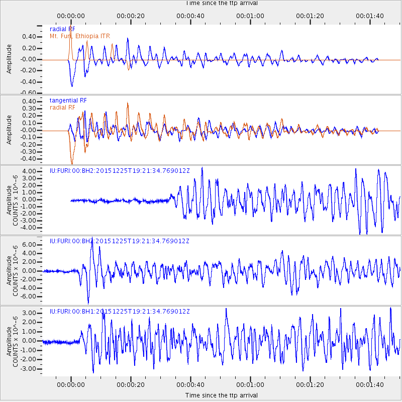
FURI Mt. Furi, Ethiopia - Earthquake Result Viewer
*The percent match for this event was below the threshold and hence no stack was calculated.
| Earthquake location: |
Afghanistan-Tajikistan Bord Reg. |
| Earthquake latitude/longitude: |
36.5/71.1 |
| Earthquake time(UTC): |
2015/12/25 (359) 19:14:48 GMT |
| Earthquake Depth: |
204 km |
| Earthquake Magnitude: |
6.2 MO |
| Earthquake Catalog/Contributor: |
NEIC PDE/NEIC ALERT |
|
| Network: |
IU Global Seismograph Network (GSN - IRIS/USGS) |
| Station: |
FURI Mt. Furi, Ethiopia |
| Lat/Lon: |
8.90 N/38.68 E |
| Elevation: |
2570 m |
|
| Distance: |
40.3 deg |
| Az: |
235.078 deg |
| Baz: |
41.95 deg |
| Ray Param: |
$rayparam |
*The percent match for this event was below the threshold and hence was not used in the summary stack. |
|
| Radial Match: |
74.385895 % |
| Radial Bump: |
400 |
| Transverse Match: |
73.22772 % |
| Transverse Bump: |
400 |
| SOD ConfigId: |
1259291 |
| Insert Time: |
2016-01-08 19:47:01.409 +0000 |
| GWidth: |
2.5 |
| Max Bumps: |
400 |
| Tol: |
0.001 |
|
Signal To Noise
| Channel | StoN | STA | LTA |
| IU:FURI:00:BHZ:20151225T19:21:34.769012Z | 6.969327 | 1.0245146E-6 | 1.4700338E-7 |
| IU:FURI:00:BH1:20151225T19:21:34.769012Z | 2.8963892 | 3.7757806E-7 | 1.3036164E-7 |
| IU:FURI:00:BH2:20151225T19:21:34.769012Z | 2.725621 | 3.246336E-7 | 1.1910444E-7 |
| Arrivals |
| Ps | |
| PpPs | |
| PsPs/PpSs | |


