You are here: Home > Network List > TA - USArray Transportable Network (new EarthScope stations) Stations List
> Station 113A Mohawk Valley, Roll, AZ, USA > Earthquake Result Viewer
113A Mohawk Valley, Roll, AZ, USA - Earthquake Result Viewer

| Earthquake location: |
South Of Fiji Islands |
| Earthquake latitude/longitude: |
-25.8/179.5 |
| Earthquake time(UTC): |
2007/10/16 (289) 21:05:43 GMT |
| Earthquake Depth: |
509 km |
| Earthquake Magnitude: |
6.2 MB, 6.6 MW, 6.5 MW |
| Earthquake Catalog/Contributor: |
WHDF/NEIC |
|
| Network: |
TA USArray Transportable Network (new EarthScope stations) |
| Station: |
113A Mohawk Valley, Roll, AZ, USA |
| Lat/Lon: |
32.77 N/113.77 W |
| Elevation: |
118 m |
|
| Distance: |
86.1 deg |
| Az: |
50.859 deg |
| Baz: |
236.101 deg |
| Ray Param: |
0.04285523 |
| Estimated Moho Depth: |
28.75 km |
| Estimated Crust Vp/Vs: |
1.69 |
| Assumed Crust Vp: |
6.264 km/s |
| Estimated Crust Vs: |
3.701 km/s |
| Estimated Crust Poisson's Ratio: |
0.23 |
|
| Radial Match: |
90.169754 % |
| Radial Bump: |
291 |
| Transverse Match: |
82.1119 % |
| Transverse Bump: |
363 |
| SOD ConfigId: |
2564 |
| Insert Time: |
2010-03-06 00:41:08.001 +0000 |
| GWidth: |
2.5 |
| Max Bumps: |
400 |
| Tol: |
0.001 |
|
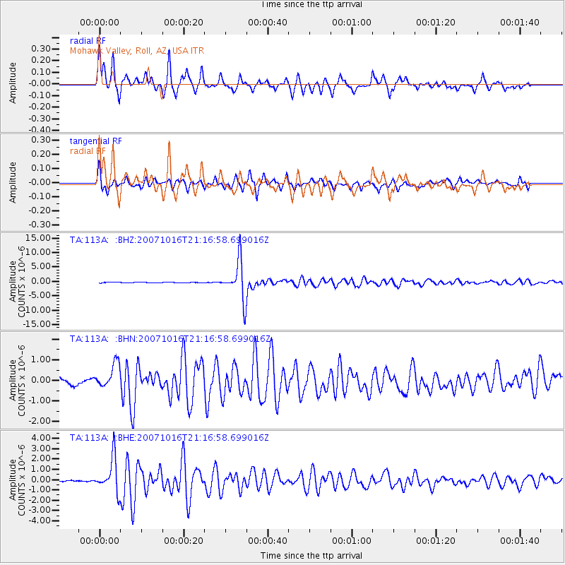
Signal To Noise
| Channel | StoN | STA | LTA |
| TA:113A: :BHN:20071016T21:16:58.699016Z | 3.0847306 | 6.5058816E-7 | 2.1090598E-7 |
| TA:113A: :BHE:20071016T21:16:58.699016Z | 16.796822 | 1.71256E-6 | 1.0195738E-7 |
| TA:113A: :BHZ:20071016T21:16:58.699016Z | 60.06383 | 7.039951E-6 | 1.1720783E-7 |
| Arrivals |
| Ps | 3.2 SECOND |
| PpPs | 12 SECOND |
| PsPs/PpSs | 15 SECOND |


