You are here: Home > Network List > TA - USArray Transportable Network (new EarthScope stations) Stations List
> Station M53A WI Miller and Sons, Farmdale, OH, USA > Earthquake Result Viewer
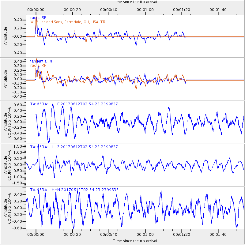
M53A WI Miller and Sons, Farmdale, OH, USA - Earthquake Result Viewer
*The percent match for this event was below the threshold and hence no stack was calculated.
| Earthquake location: |
Near Coast Of Central Chile |
| Earthquake latitude/longitude: |
-31.5/-71.8 |
| Earthquake time(UTC): |
2017/06/12 (163) 02:43:26 GMT |
| Earthquake Depth: |
26 km |
| Earthquake Magnitude: |
5.6 Mww |
| Earthquake Catalog/Contributor: |
NEIC PDE/us |
|
| Network: |
TA USArray Transportable Network (new EarthScope stations) |
| Station: |
M53A WI Miller and Sons, Farmdale, OH, USA |
| Lat/Lon: |
41.44 N/80.68 W |
| Elevation: |
334 m |
|
| Distance: |
73.0 deg |
| Az: |
353.005 deg |
| Baz: |
172.048 deg |
| Ray Param: |
$rayparam |
*The percent match for this event was below the threshold and hence was not used in the summary stack. |
|
| Radial Match: |
62.118923 % |
| Radial Bump: |
400 |
| Transverse Match: |
72.8531 % |
| Transverse Bump: |
360 |
| SOD ConfigId: |
13570011 |
| Insert Time: |
2019-04-28 04:31:56.683 +0000 |
| GWidth: |
2.5 |
| Max Bumps: |
400 |
| Tol: |
0.001 |
|
Signal To Noise
| Channel | StoN | STA | LTA |
| TA:M53A: :HHZ:20170612T02:54:23.239983Z | 1.9305028 | 6.132011E-7 | 3.1763804E-7 |
| TA:M53A: :HHN:20170612T02:54:23.239983Z | 1.4574177 | 2.958124E-7 | 2.0297024E-7 |
| TA:M53A: :HHE:20170612T02:54:23.239983Z | 0.45471543 | 1.6431186E-7 | 3.6135097E-7 |
| Arrivals |
| Ps | |
| PpPs | |
| PsPs/PpSs | |


