You are here: Home > Network List > TA - USArray Transportable Network (new EarthScope stations) Stations List
> Station 113A Mohawk Valley, Roll, AZ, USA > Earthquake Result Viewer
113A Mohawk Valley, Roll, AZ, USA - Earthquake Result Viewer

| Earthquake location: |
Near West Coast Of Honshu, Japan |
| Earthquake latitude/longitude: |
37.5/138.5 |
| Earthquake time(UTC): |
2007/07/16 (197) 06:37:40 GMT |
| Earthquake Depth: |
15 km |
| Earthquake Magnitude: |
5.7 MB, 5.1 MS, 5.7 MW, 5.6 MW |
| Earthquake Catalog/Contributor: |
WHDF/NEIC |
|
| Network: |
TA USArray Transportable Network (new EarthScope stations) |
| Station: |
113A Mohawk Valley, Roll, AZ, USA |
| Lat/Lon: |
32.77 N/113.77 W |
| Elevation: |
118 m |
|
| Distance: |
83.0 deg |
| Az: |
53.938 deg |
| Baz: |
310.263 deg |
| Ray Param: |
0.046496864 |
| Estimated Moho Depth: |
66.0 km |
| Estimated Crust Vp/Vs: |
1.91 |
| Assumed Crust Vp: |
6.264 km/s |
| Estimated Crust Vs: |
3.284 km/s |
| Estimated Crust Poisson's Ratio: |
0.31 |
|
| Radial Match: |
80.36582 % |
| Radial Bump: |
370 |
| Transverse Match: |
61.868153 % |
| Transverse Bump: |
400 |
| SOD ConfigId: |
2564 |
| Insert Time: |
2010-03-06 00:41:45.014 +0000 |
| GWidth: |
2.5 |
| Max Bumps: |
400 |
| Tol: |
0.001 |
|
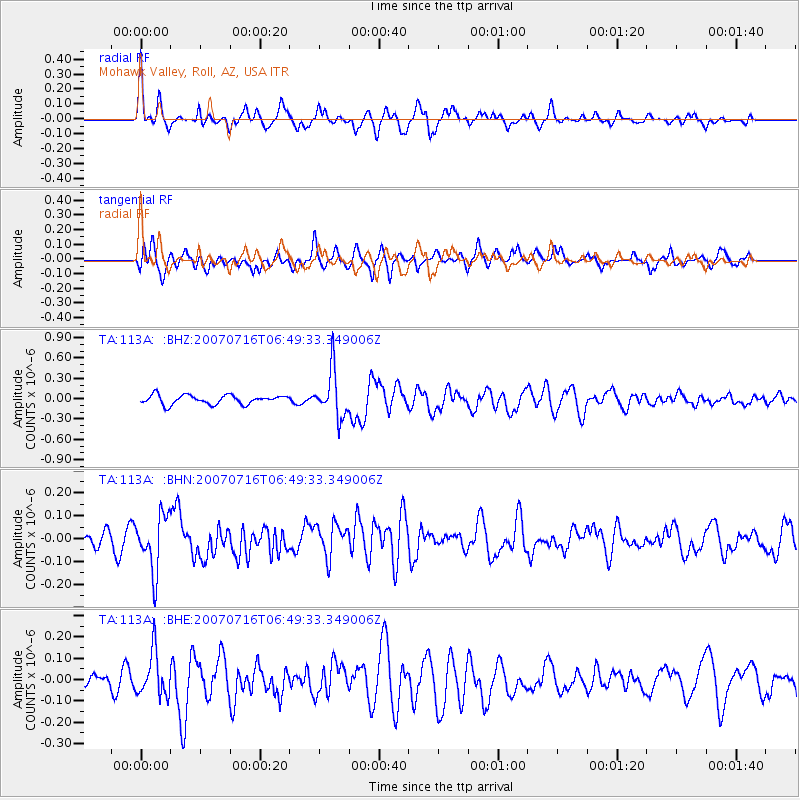
Signal To Noise
| Channel | StoN | STA | LTA |
| TA:113A: :BHN:20070716T06:49:33.349006Z | 2.11602 | 1.2182576E-7 | 5.7573065E-8 |
| TA:113A: :BHE:20070716T06:49:33.349006Z | 2.277534 | 1.0400345E-7 | 4.5664937E-8 |
| TA:113A: :BHZ:20070716T06:49:33.349006Z | 5.118698 | 3.4265346E-7 | 6.6941524E-8 |
| Arrivals |
| Ps | 9.8 SECOND |
| PpPs | 30 SECOND |
| PsPs/PpSs | 40 SECOND |


