You are here: Home > Network List > 5H - Central Virginia and South Carolina seismic monitoring experiment Stations List
> Station PWTN Powhatan W.M.A., VA > Earthquake Result Viewer
PWTN Powhatan W.M.A., VA - Earthquake Result Viewer
| Earthquake location: |
Aegean Sea |
| Earthquake latitude/longitude: |
38.9/26.4 |
| Earthquake time(UTC): |
2017/06/12 (163) 12:28:38 GMT |
| Earthquake Depth: |
10 km |
| Earthquake Magnitude: |
6.3 Mww |
| Earthquake Catalog/Contributor: |
NEIC PDE/us |
|
| Network: |
5H Central Virginia and South Carolina seismic monitoring experiment |
| Station: |
PWTN Powhatan W.M.A., VA |
| Lat/Lon: |
37.53 N/77.99 W |
| Elevation: |
99 m |
|
| Distance: |
76.9 deg |
| Az: |
307.756 deg |
| Baz: |
50.867 deg |
| Ray Param: |
0.050657317 |
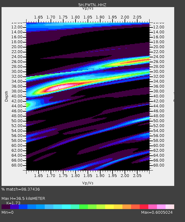
| Estimated Moho Depth: |
36.5 km |
| Estimated Crust Vp/Vs: |
1.73 |
| Assumed Crust Vp: |
6.565 km/s |
| Estimated Crust Vs: |
3.795 km/s |
| Estimated Crust Poisson's Ratio: |
0.25 |
|
| Radial Match: |
86.37436 % |
| Radial Bump: |
312 |
| Transverse Match: |
71.98285 % |
| Transverse Bump: |
400 |
| SOD ConfigId: |
13570011 |
| Insert Time: |
2019-04-28 04:33:43.005 +0000 |
| GWidth: |
2.5 |
| Max Bumps: |
400 |
| Tol: |
0.001 |
|

Signal To Noise
| Channel | StoN | STA | LTA |
| 5H:PWTN: :HHZ:20170612T12:39:59.995012Z | 10.89786 | 1.5814245E-6 | 1.451133E-7 |
| 5H:PWTN: :HHN:20170612T12:39:59.995012Z | 3.8502016 | 2.7309613E-7 | 7.093034E-8 |
| 5H:PWTN: :HHE:20170612T12:39:59.995012Z | 3.6494465 | 4.0863637E-7 | 1.1197215E-7 |
| Arrivals |
| Ps | 4.2 SECOND |
| PpPs | 15 SECOND |
| PsPs/PpSs | 19 SECOND |


