You are here: Home > Network List > AK - Alaska Regional Network Stations List
> Station CHUM Lake Minchumina Broadband > Earthquake Result Viewer
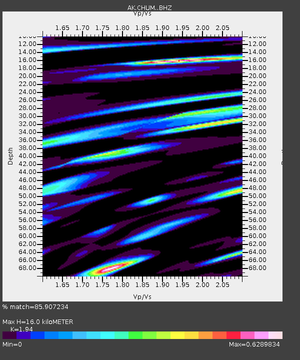
CHUM Lake Minchumina Broadband - Earthquake Result Viewer
| Earthquake location: |
Aegean Sea |
| Earthquake latitude/longitude: |
38.9/26.4 |
| Earthquake time(UTC): |
2017/06/12 (163) 12:28:38 GMT |
| Earthquake Depth: |
10 km |
| Earthquake Magnitude: |
6.3 Mww |
| Earthquake Catalog/Contributor: |
NEIC PDE/us |
|
| Network: |
AK Alaska Regional Network |
| Station: |
CHUM Lake Minchumina Broadband |
| Lat/Lon: |
63.88 N/152.31 W |
| Elevation: |
58 m |
|
| Distance: |
77.5 deg |
| Az: |
359.401 deg |
| Baz: |
1.056 deg |
| Ray Param: |
0.050265938 |
| Estimated Moho Depth: |
16.0 km |
| Estimated Crust Vp/Vs: |
1.94 |
| Assumed Crust Vp: |
6.566 km/s |
| Estimated Crust Vs: |
3.385 km/s |
| Estimated Crust Poisson's Ratio: |
0.32 |
|
| Radial Match: |
85.907234 % |
| Radial Bump: |
400 |
| Transverse Match: |
82.291985 % |
| Transverse Bump: |
400 |
| SOD ConfigId: |
13570011 |
| Insert Time: |
2019-04-28 04:34:07.444 +0000 |
| GWidth: |
2.5 |
| Max Bumps: |
400 |
| Tol: |
0.001 |
|

Signal To Noise
| Channel | StoN | STA | LTA |
| AK:CHUM: :BHZ:20170612T12:40:03.268022Z | 64.68482 | 3.2364849E-6 | 5.003469E-8 |
| AK:CHUM: :BHN:20170612T12:40:03.268022Z | 9.473174 | 7.473271E-7 | 7.8888775E-8 |
| AK:CHUM: :BHE:20170612T12:40:03.268022Z | 2.4790294 | 2.111697E-7 | 8.5182414E-8 |
| Arrivals |
| Ps | 2.4 SECOND |
| PpPs | 7.0 SECOND |
| PsPs/PpSs | 9.3 SECOND |


