You are here: Home > Network List > TA - USArray Transportable Network (new EarthScope stations) Stations List
> Station 113A Mohawk Valley, Roll, AZ, USA > Earthquake Result Viewer
113A Mohawk Valley, Roll, AZ, USA - Earthquake Result Viewer
| Earthquake location: |
Colombia |
| Earthquake latitude/longitude: |
4.3/-73.8 |
| Earthquake time(UTC): |
2008/05/24 (145) 19:20:42 GMT |
| Earthquake Depth: |
8.9 km |
| Earthquake Magnitude: |
5.6 MB, 5.6 MS, 5.9 MW, 5.9 MW |
| Earthquake Catalog/Contributor: |
WHDF/NEIC |
|
| Network: |
TA USArray Transportable Network (new EarthScope stations) |
| Station: |
113A Mohawk Valley, Roll, AZ, USA |
| Lat/Lon: |
32.77 N/113.77 W |
| Elevation: |
118 m |
|
| Distance: |
46.8 deg |
| Az: |
312.065 deg |
| Baz: |
118.517 deg |
| Ray Param: |
0.07038707 |
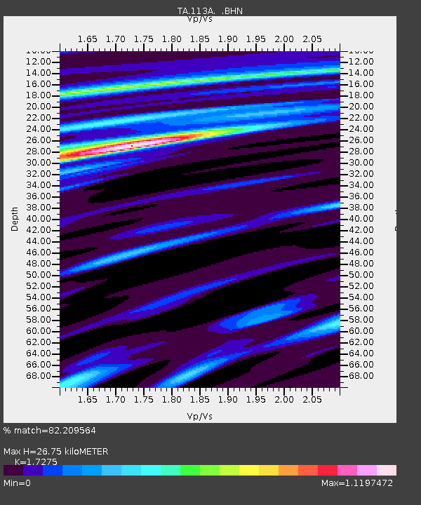
| Estimated Moho Depth: |
26.75 km |
| Estimated Crust Vp/Vs: |
1.73 |
| Assumed Crust Vp: |
6.264 km/s |
| Estimated Crust Vs: |
3.626 km/s |
| Estimated Crust Poisson's Ratio: |
0.25 |
|
| Radial Match: |
82.209564 % |
| Radial Bump: |
400 |
| Transverse Match: |
65.61248 % |
| Transverse Bump: |
378 |
| SOD ConfigId: |
2504 |
| Insert Time: |
2010-03-06 00:42:11.083 +0000 |
| GWidth: |
2.5 |
| Max Bumps: |
400 |
| Tol: |
0.001 |
|

Signal To Noise
| Channel | StoN | STA | LTA |
| TA:113A: :BHN:20080524T19:28:41.775004Z | 2.2904959 | 6.0085557E-7 | 2.6232553E-7 |
| TA:113A: :BHE:20080524T19:28:41.775004Z | 1.0782851 | 3.463786E-7 | 3.21231E-7 |
| TA:113A: :BHZ:20080524T19:28:41.775004Z | 1.3335522 | 5.843089E-7 | 4.381597E-7 |
| Arrivals |
| Ps | 3.3 SECOND |
| PpPs | 11 SECOND |
| PsPs/PpSs | 14 SECOND |


