You are here: Home > Network List > TA - USArray Transportable Network (new EarthScope stations) Stations List
> Station 113A Mohawk Valley, Roll, AZ, USA > Earthquake Result Viewer
113A Mohawk Valley, Roll, AZ, USA - Earthquake Result Viewer

| Earthquake location: |
Iceland |
| Earthquake latitude/longitude: |
64.0/-21.0 |
| Earthquake time(UTC): |
2008/05/29 (150) 15:46:00 GMT |
| Earthquake Depth: |
10 km |
| Earthquake Magnitude: |
6.0 MB, 6.2 MS, 6.3 MW, 6.2 MW |
| Earthquake Catalog/Contributor: |
WHDF/NEIC |
|
| Network: |
TA USArray Transportable Network (new EarthScope stations) |
| Station: |
113A Mohawk Valley, Roll, AZ, USA |
| Lat/Lon: |
32.77 N/113.77 W |
| Elevation: |
118 m |
|
| Distance: |
62.2 deg |
| Az: |
288.019 deg |
| Baz: |
29.829 deg |
| Ray Param: |
0.06035442 |
| Estimated Moho Depth: |
28.75 km |
| Estimated Crust Vp/Vs: |
1.66 |
| Assumed Crust Vp: |
6.264 km/s |
| Estimated Crust Vs: |
3.779 km/s |
| Estimated Crust Poisson's Ratio: |
0.21 |
|
| Radial Match: |
85.64283 % |
| Radial Bump: |
280 |
| Transverse Match: |
56.19209 % |
| Transverse Bump: |
327 |
| SOD ConfigId: |
2504 |
| Insert Time: |
2010-03-06 00:42:12.741 +0000 |
| GWidth: |
2.5 |
| Max Bumps: |
400 |
| Tol: |
0.001 |
|
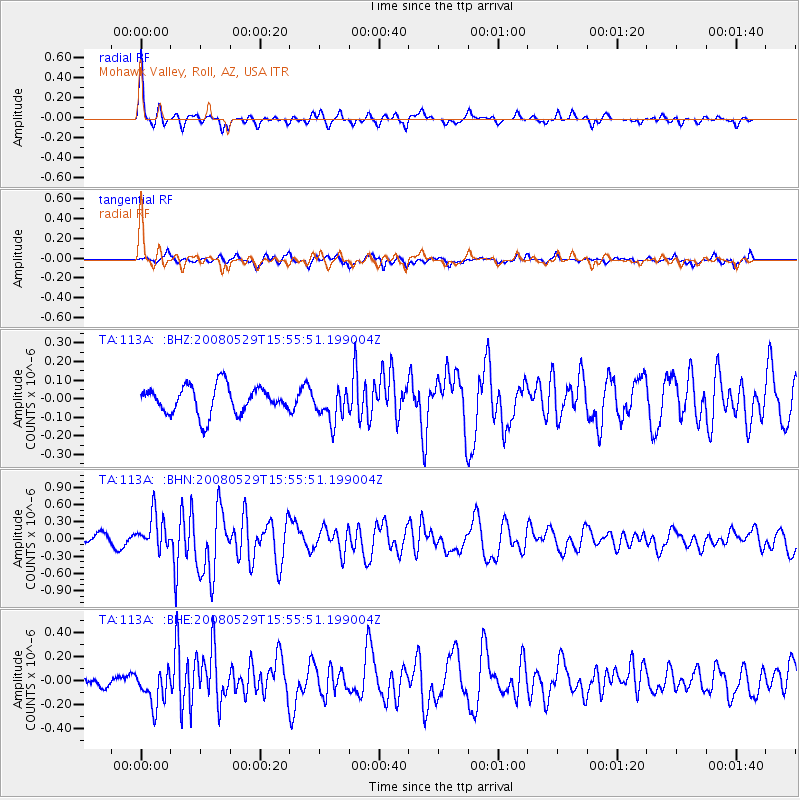
Signal To Noise
| Channel | StoN | STA | LTA |
| TA:113A: :BHN:20080529T15:55:51.199004Z | 3.0534127 | 3.0303565E-7 | 9.92449E-8 |
| TA:113A: :BHE:20080529T15:55:51.199004Z | 1.8128847 | 1.4568623E-7 | 8.036155E-8 |
| TA:113A: :BHZ:20080529T15:55:51.199004Z | 1.1862084 | 8.828839E-8 | 7.4429074E-8 |
| Arrivals |
| Ps | 3.2 SECOND |
| PpPs | 12 SECOND |
| PsPs/PpSs | 15 SECOND |


