You are here: Home > Network List > TA - USArray Transportable Network (new EarthScope stations) Stations List
> Station 113A Mohawk Valley, Roll, AZ, USA > Earthquake Result Viewer
113A Mohawk Valley, Roll, AZ, USA - Earthquake Result Viewer
| Earthquake location: |
Colombia |
| Earthquake latitude/longitude: |
4.8/-75.5 |
| Earthquake time(UTC): |
2008/09/13 (257) 09:32:01 GMT |
| Earthquake Depth: |
133 km |
| Earthquake Magnitude: |
5.9 MB, 5.7 MW, 5.7 MW |
| Earthquake Catalog/Contributor: |
WHDF/NEIC |
|
| Network: |
TA USArray Transportable Network (new EarthScope stations) |
| Station: |
113A Mohawk Valley, Roll, AZ, USA |
| Lat/Lon: |
32.77 N/113.77 W |
| Elevation: |
118 m |
|
| Distance: |
45.2 deg |
| Az: |
312.737 deg |
| Baz: |
119.685 deg |
| Ray Param: |
0.07092078 |
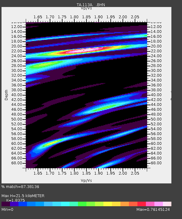
| Estimated Moho Depth: |
21.5 km |
| Estimated Crust Vp/Vs: |
1.84 |
| Assumed Crust Vp: |
6.264 km/s |
| Estimated Crust Vs: |
3.409 km/s |
| Estimated Crust Poisson's Ratio: |
0.29 |
|
| Radial Match: |
87.38136 % |
| Radial Bump: |
393 |
| Transverse Match: |
69.852356 % |
| Transverse Bump: |
400 |
| SOD ConfigId: |
2504 |
| Insert Time: |
2010-03-06 00:42:45.140 +0000 |
| GWidth: |
2.5 |
| Max Bumps: |
400 |
| Tol: |
0.001 |
|
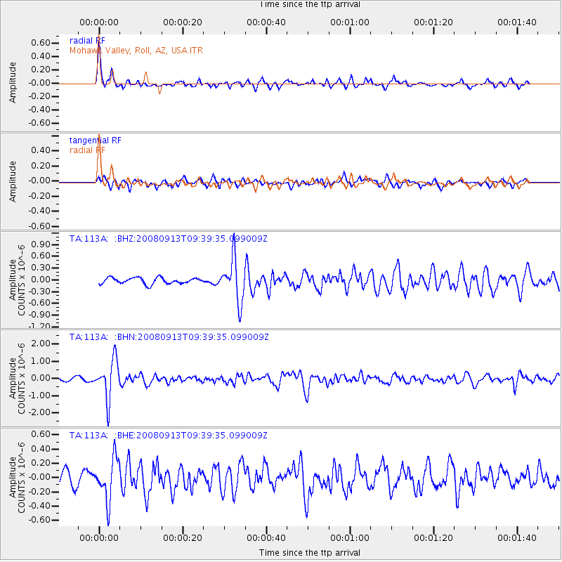
Signal To Noise
| Channel | StoN | STA | LTA |
| TA:113A: :BHN:20080913T09:39:35.099009Z | 8.529819 | 1.1683152E-6 | 1.3696835E-7 |
| TA:113A: :BHE:20080913T09:39:35.099009Z | 3.4367704 | 3.014077E-7 | 8.7700855E-8 |
| TA:113A: :BHZ:20080913T09:39:35.099009Z | 7.2353463 | 5.58611E-7 | 7.720584E-8 |
| Arrivals |
| Ps | 3.0 SECOND |
| PpPs | 9.2 SECOND |
| PsPs/PpSs | 12 SECOND |


