You are here: Home > Network List > CN - Canadian National Seismograph Network Stations List
> Station CLRS Cowichan Lake Research St, BC, CA > Earthquake Result Viewer
CLRS Cowichan Lake Research St, BC, CA - Earthquake Result Viewer
| Earthquake location: |
Aegean Sea |
| Earthquake latitude/longitude: |
38.9/26.4 |
| Earthquake time(UTC): |
2017/06/12 (163) 12:28:38 GMT |
| Earthquake Depth: |
10 km |
| Earthquake Magnitude: |
6.3 Mww |
| Earthquake Catalog/Contributor: |
NEIC PDE/us |
|
| Network: |
CN Canadian National Seismograph Network |
| Station: |
CLRS Cowichan Lake Research St, BC, CA |
| Lat/Lon: |
48.82 N/124.13 W |
| Elevation: |
174 m |
|
| Distance: |
88.8 deg |
| Az: |
340.999 deg |
| Baz: |
22.595 deg |
| Ray Param: |
0.04231966 |
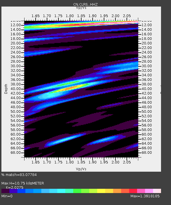
| Estimated Moho Depth: |
10.75 km |
| Estimated Crust Vp/Vs: |
2.03 |
| Assumed Crust Vp: |
6.391 km/s |
| Estimated Crust Vs: |
3.152 km/s |
| Estimated Crust Poisson's Ratio: |
0.34 |
|
| Radial Match: |
83.07784 % |
| Radial Bump: |
400 |
| Transverse Match: |
56.911064 % |
| Transverse Bump: |
400 |
| SOD ConfigId: |
13570011 |
| Insert Time: |
2019-04-28 04:36:21.517 +0000 |
| GWidth: |
2.5 |
| Max Bumps: |
400 |
| Tol: |
0.001 |
|

Signal To Noise
| Channel | StoN | STA | LTA |
| CN:CLRS: :HHZ:20170612T12:41:01.229998Z | 6.6435804 | 1.2673751E-6 | 1.9076688E-7 |
| CN:CLRS: :HHN:20170612T12:41:01.229998Z | 3.439005 | 4.955065E-7 | 1.4408427E-7 |
| CN:CLRS: :HHE:20170612T12:41:01.229998Z | 1.4341229 | 2.4360318E-7 | 1.6986212E-7 |
| Arrivals |
| Ps | 1.8 SECOND |
| PpPs | 5.0 SECOND |
| PsPs/PpSs | 6.8 SECOND |


