You are here: Home > Network List > CN - Canadian National Seismograph Network Stations List
> Station NAB2 Zama Lookout Tower, High Level Alberta > Earthquake Result Viewer
NAB2 Zama Lookout Tower, High Level Alberta - Earthquake Result Viewer
| Earthquake location: |
Aegean Sea |
| Earthquake latitude/longitude: |
38.9/26.4 |
| Earthquake time(UTC): |
2017/06/12 (163) 12:28:38 GMT |
| Earthquake Depth: |
10 km |
| Earthquake Magnitude: |
6.3 Mww |
| Earthquake Catalog/Contributor: |
NEIC PDE/us |
|
| Network: |
CN Canadian National Seismograph Network |
| Station: |
NAB2 Zama Lookout Tower, High Level Alberta |
| Lat/Lon: |
58.60 N/119.17 W |
| Elevation: |
646 m |
|
| Distance: |
78.7 deg |
| Az: |
342.406 deg |
| Baz: |
26.758 deg |
| Ray Param: |
0.04948414 |
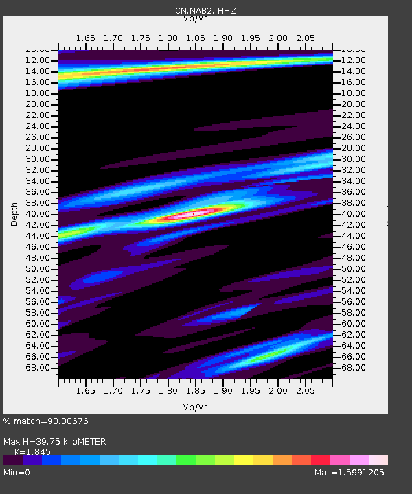
| Estimated Moho Depth: |
39.75 km |
| Estimated Crust Vp/Vs: |
1.85 |
| Assumed Crust Vp: |
6.444 km/s |
| Estimated Crust Vs: |
3.493 km/s |
| Estimated Crust Poisson's Ratio: |
0.29 |
|
| Radial Match: |
90.08676 % |
| Radial Bump: |
277 |
| Transverse Match: |
71.45074 % |
| Transverse Bump: |
399 |
| SOD ConfigId: |
13570011 |
| Insert Time: |
2019-04-28 04:36:51.191 +0000 |
| GWidth: |
2.5 |
| Max Bumps: |
400 |
| Tol: |
0.001 |
|

Signal To Noise
| Channel | StoN | STA | LTA |
| CN:NAB2: :HHZ:20170612T12:40:09.610002Z | 14.935348 | 4.095278E-6 | 2.7420037E-7 |
| CN:NAB2: :HHN:20170612T12:40:09.610002Z | 4.892596 | 9.4243E-7 | 1.9262372E-7 |
| CN:NAB2: :HHE:20170612T12:40:09.610002Z | 3.166567 | 5.6833335E-7 | 1.7947931E-7 |
| Arrivals |
| Ps | 5.4 SECOND |
| PpPs | 17 SECOND |
| PsPs/PpSs | 22 SECOND |


