You are here: Home > Network List > US - United States National Seismic Network Stations List
> Station GLMI Grayling, Michigan, USA > Earthquake Result Viewer
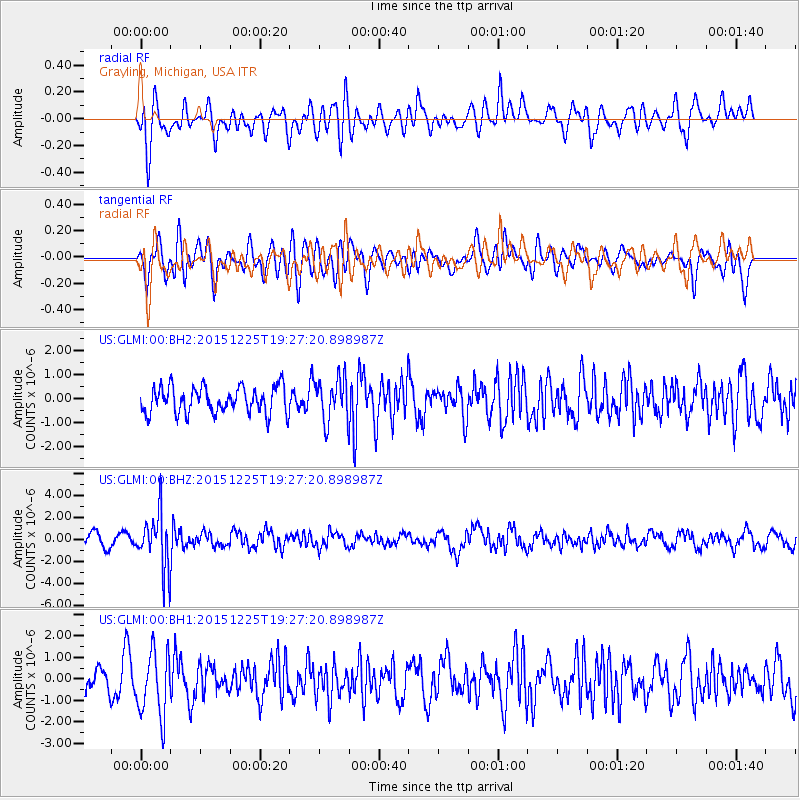
GLMI Grayling, Michigan, USA - Earthquake Result Viewer
*The percent match for this event was below the threshold and hence no stack was calculated.
| Earthquake location: |
Afghanistan-Tajikistan Bord Reg. |
| Earthquake latitude/longitude: |
36.5/71.1 |
| Earthquake time(UTC): |
2015/12/25 (359) 19:14:48 GMT |
| Earthquake Depth: |
204 km |
| Earthquake Magnitude: |
6.2 MO |
| Earthquake Catalog/Contributor: |
NEIC PDE/NEIC ALERT |
|
| Network: |
US United States National Seismic Network |
| Station: |
GLMI Grayling, Michigan, USA |
| Lat/Lon: |
44.82 N/84.62 W |
| Elevation: |
387 m |
|
| Distance: |
96.1 deg |
| Az: |
342.907 deg |
| Baz: |
19.435 deg |
| Ray Param: |
$rayparam |
*The percent match for this event was below the threshold and hence was not used in the summary stack. |
|
| Radial Match: |
64.48891 % |
| Radial Bump: |
400 |
| Transverse Match: |
49.73974 % |
| Transverse Bump: |
400 |
| SOD ConfigId: |
1259291 |
| Insert Time: |
2016-01-08 19:49:52.521 +0000 |
| GWidth: |
2.5 |
| Max Bumps: |
400 |
| Tol: |
0.001 |
|
Signal To Noise
| Channel | StoN | STA | LTA |
| US:GLMI:00:BHZ:20151225T19:27:20.898987Z | 5.683467 | 2.461813E-6 | 4.3315342E-7 |
| US:GLMI:00:BH1:20151225T19:27:20.898987Z | 2.2550936 | 1.5062208E-6 | 6.679194E-7 |
| US:GLMI:00:BH2:20151225T19:27:20.898987Z | 1.6388208 | 8.9402437E-7 | 5.455291E-7 |
| Arrivals |
| Ps | |
| PpPs | |
| PsPs/PpSs | |


