You are here: Home > Network List > TA - USArray Transportable Network (new EarthScope stations) Stations List
> Station 113A Mohawk Valley, Roll, AZ, USA > Earthquake Result Viewer
113A Mohawk Valley, Roll, AZ, USA - Earthquake Result Viewer
| Earthquake location: |
Santa Cruz Islands |
| Earthquake latitude/longitude: |
-12.2/166.0 |
| Earthquake time(UTC): |
2009/10/23 (296) 15:14:13 GMT |
| Earthquake Depth: |
31 km |
| Earthquake Magnitude: |
5.6 MB, 5.8 MS, 6.0 MW, 5.9 MW |
| Earthquake Catalog/Contributor: |
WHDF/NEIC |
|
| Network: |
TA USArray Transportable Network (new EarthScope stations) |
| Station: |
113A Mohawk Valley, Roll, AZ, USA |
| Lat/Lon: |
32.77 N/113.77 W |
| Elevation: |
118 m |
|
| Distance: |
88.4 deg |
| Az: |
56.15 deg |
| Baz: |
254.531 deg |
| Ray Param: |
0.04255113 |
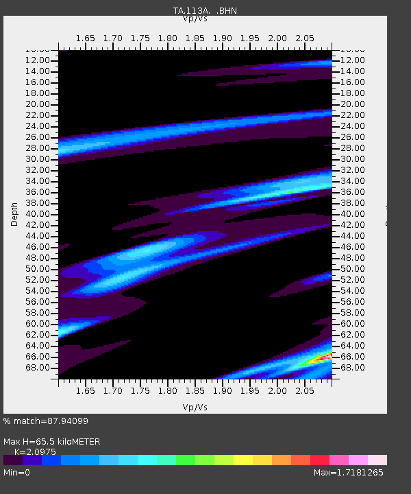
| Estimated Moho Depth: |
65.5 km |
| Estimated Crust Vp/Vs: |
2.10 |
| Assumed Crust Vp: |
6.264 km/s |
| Estimated Crust Vs: |
2.986 km/s |
| Estimated Crust Poisson's Ratio: |
0.35 |
|
| Radial Match: |
87.94099 % |
| Radial Bump: |
366 |
| Transverse Match: |
60.284767 % |
| Transverse Bump: |
400 |
| SOD ConfigId: |
2622 |
| Insert Time: |
2010-03-06 00:43:21.765 +0000 |
| GWidth: |
2.5 |
| Max Bumps: |
400 |
| Tol: |
0.001 |
|
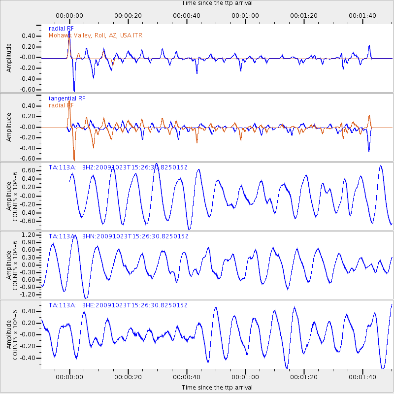
Signal To Noise
| Channel | StoN | STA | LTA |
| TA:113A: :BHN:20091023T15:26:30.825015Z | 1.6128563 | 7.847929E-7 | 4.8658575E-7 |
| TA:113A: :BHE:20091023T15:26:30.825015Z | 1.454981 | 2.4060483E-7 | 1.6536632E-7 |
| TA:113A: :BHZ:20091023T15:26:30.825015Z | 1.2639183 | 5.096159E-7 | 4.032032E-7 |
| Arrivals |
| Ps | 12 SECOND |
| PpPs | 32 SECOND |
| PsPs/PpSs | 44 SECOND |


