You are here: Home > Network List > CN - Canadian National Seismograph Network Stations List
> Station SUBO Sudbury, ON, CA > Earthquake Result Viewer
SUBO Sudbury, ON, CA - Earthquake Result Viewer
| Earthquake location: |
Aegean Sea |
| Earthquake latitude/longitude: |
38.9/26.4 |
| Earthquake time(UTC): |
2017/06/12 (163) 12:28:38 GMT |
| Earthquake Depth: |
10 km |
| Earthquake Magnitude: |
6.3 Mww |
| Earthquake Catalog/Contributor: |
NEIC PDE/us |
|
| Network: |
CN Canadian National Seismograph Network |
| Station: |
SUBO Sudbury, ON, CA |
| Lat/Lon: |
46.61 N/81.13 W |
| Elevation: |
281 m |
|
| Distance: |
73.0 deg |
| Az: |
316.577 deg |
| Baz: |
51.05 deg |
| Ray Param: |
0.05326543 |
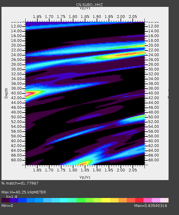
| Estimated Moho Depth: |
40.25 km |
| Estimated Crust Vp/Vs: |
1.60 |
| Assumed Crust Vp: |
6.467 km/s |
| Estimated Crust Vs: |
4.042 km/s |
| Estimated Crust Poisson's Ratio: |
0.18 |
|
| Radial Match: |
81.77967 % |
| Radial Bump: |
247 |
| Transverse Match: |
56.502087 % |
| Transverse Bump: |
374 |
| SOD ConfigId: |
13570011 |
| Insert Time: |
2019-04-28 04:37:12.838 +0000 |
| GWidth: |
2.5 |
| Max Bumps: |
400 |
| Tol: |
0.001 |
|

Signal To Noise
| Channel | StoN | STA | LTA |
| CN:SUBO: :HHZ:20170612T12:39:37.550005Z | 10.719992 | 2.242061E-6 | 2.0914766E-7 |
| CN:SUBO: :HHN:20170612T12:39:37.550005Z | 2.744423 | 4.763083E-7 | 1.73555E-7 |
| CN:SUBO: :HHE:20170612T12:39:37.550005Z | 3.1159053 | 6.9200354E-7 | 2.2208746E-7 |
| Arrivals |
| Ps | 3.9 SECOND |
| PpPs | 16 SECOND |
| PsPs/PpSs | 19 SECOND |


