You are here: Home > Network List > DK - Danish Seismological Network Stations List
> Station NOR Station Nord, Greenland > Earthquake Result Viewer
NOR Station Nord, Greenland - Earthquake Result Viewer
| Earthquake location: |
Aegean Sea |
| Earthquake latitude/longitude: |
38.9/26.4 |
| Earthquake time(UTC): |
2017/06/12 (163) 12:28:38 GMT |
| Earthquake Depth: |
10 km |
| Earthquake Magnitude: |
6.3 Mww |
| Earthquake Catalog/Contributor: |
NEIC PDE/us |
|
| Network: |
DK Danish Seismological Network |
| Station: |
NOR Station Nord, Greenland |
| Lat/Lon: |
81.60 N/16.66 W |
| Elevation: |
36 m |
|
| Distance: |
45.3 deg |
| Az: |
351.896 deg |
| Baz: |
131.573 deg |
| Ray Param: |
0.07133901 |
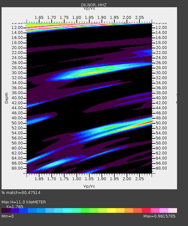
| Estimated Moho Depth: |
11.0 km |
| Estimated Crust Vp/Vs: |
1.76 |
| Assumed Crust Vp: |
6.459 km/s |
| Estimated Crust Vs: |
3.66 km/s |
| Estimated Crust Poisson's Ratio: |
0.26 |
|
| Radial Match: |
80.47514 % |
| Radial Bump: |
400 |
| Transverse Match: |
69.65537 % |
| Transverse Bump: |
400 |
| SOD ConfigId: |
13570011 |
| Insert Time: |
2019-04-28 04:37:37.800 +0000 |
| GWidth: |
2.5 |
| Max Bumps: |
400 |
| Tol: |
0.001 |
|

Signal To Noise
| Channel | StoN | STA | LTA |
| DK:NOR: :HHZ:20170612T12:36:26.179003Z | 25.314014 | 3.0479523E-6 | 1.2040573E-7 |
| DK:NOR: :HHN:20170612T12:36:26.179003Z | 9.313893 | 1.0911317E-6 | 1.17150975E-7 |
| DK:NOR: :HHE:20170612T12:36:26.179003Z | 9.384975 | 1.3300386E-6 | 1.4171998E-7 |
| Arrivals |
| Ps | 1.4 SECOND |
| PpPs | 4.4 SECOND |
| PsPs/PpSs | 5.8 SECOND |


