You are here: Home > Network List > TA - USArray Transportable Network (new EarthScope stations) Stations List
> Station 113A Mohawk Valley, Roll, AZ, USA > Earthquake Result Viewer
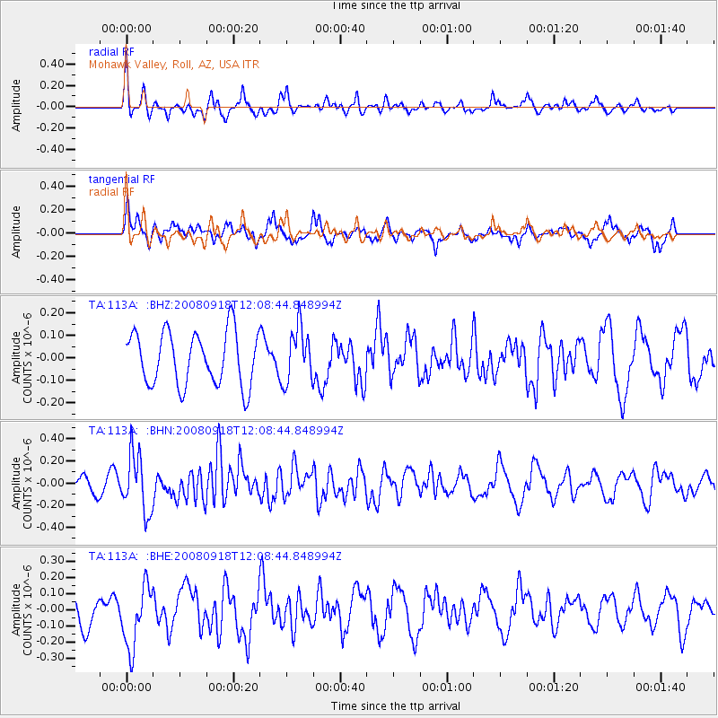
113A Mohawk Valley, Roll, AZ, USA - Earthquake Result Viewer
*The percent match for this event was below the threshold and hence no stack was calculated.
| Earthquake location: |
Near East Coast Of Kamchatka |
| Earthquake latitude/longitude: |
51.9/158.4 |
| Earthquake time(UTC): |
2008/09/18 (262) 11:58:50 GMT |
| Earthquake Depth: |
67 km |
| Earthquake Magnitude: |
5.7 MB, 5.9 MW, 5.8 MW |
| Earthquake Catalog/Contributor: |
WHDF/NEIC |
|
| Network: |
TA USArray Transportable Network (new EarthScope stations) |
| Station: |
113A Mohawk Valley, Roll, AZ, USA |
| Lat/Lon: |
32.77 N/113.77 W |
| Elevation: |
118 m |
|
| Distance: |
63.7 deg |
| Az: |
69.86 deg |
| Baz: |
316.358 deg |
| Ray Param: |
$rayparam |
*The percent match for this event was below the threshold and hence was not used in the summary stack. |
|
| Radial Match: |
59.74943 % |
| Radial Bump: |
358 |
| Transverse Match: |
61.05217 % |
| Transverse Bump: |
378 |
| SOD ConfigId: |
2504 |
| Insert Time: |
2010-03-06 00:44:16.463 +0000 |
| GWidth: |
2.5 |
| Max Bumps: |
400 |
| Tol: |
0.001 |
|
Signal To Noise
| Channel | StoN | STA | LTA |
| TA:113A: :BHN:20080918T12:08:44.848994Z | 2.3039982 | 2.6430342E-7 | 1.14715114E-7 |
| TA:113A: :BHE:20080918T12:08:44.848994Z | 2.1415598 | 1.973477E-7 | 9.215139E-8 |
| TA:113A: :BHZ:20080918T12:08:44.848994Z | 1.0323389 | 1.2203267E-7 | 1.1820991E-7 |
| Arrivals |
| Ps | |
| PpPs | |
| PsPs/PpSs | |


