You are here: Home > Network List > N4 - Central and EAstern US Network Stations List
> Station J47A Sunmer, MI, USA > Earthquake Result Viewer
J47A Sunmer, MI, USA - Earthquake Result Viewer
| Earthquake location: |
Aegean Sea |
| Earthquake latitude/longitude: |
38.9/26.4 |
| Earthquake time(UTC): |
2017/06/12 (163) 12:28:38 GMT |
| Earthquake Depth: |
10 km |
| Earthquake Magnitude: |
6.3 Mww |
| Earthquake Catalog/Contributor: |
NEIC PDE/us |
|
| Network: |
N4 Central and EAstern US Network |
| Station: |
J47A Sunmer, MI, USA |
| Lat/Lon: |
43.24 N/84.82 W |
| Elevation: |
236 m |
|
| Distance: |
77.2 deg |
| Az: |
315.675 deg |
| Baz: |
48.22 deg |
| Ray Param: |
0.050469637 |
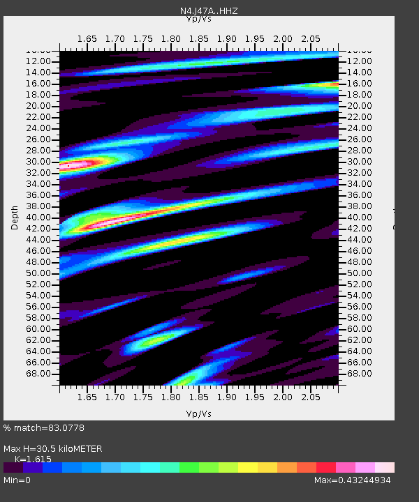
| Estimated Moho Depth: |
30.5 km |
| Estimated Crust Vp/Vs: |
1.62 |
| Assumed Crust Vp: |
6.483 km/s |
| Estimated Crust Vs: |
4.014 km/s |
| Estimated Crust Poisson's Ratio: |
0.19 |
|
| Radial Match: |
83.0778 % |
| Radial Bump: |
400 |
| Transverse Match: |
55.870556 % |
| Transverse Bump: |
400 |
| SOD ConfigId: |
13570011 |
| Insert Time: |
2019-04-28 04:39:43.259 +0000 |
| GWidth: |
2.5 |
| Max Bumps: |
400 |
| Tol: |
0.001 |
|

Signal To Noise
| Channel | StoN | STA | LTA |
| N4:J47A: :HHZ:20170612T12:40:01.579973Z | 8.474186 | 2.6636626E-6 | 3.1432668E-7 |
| N4:J47A: :HHN:20170612T12:40:01.579973Z | 1.7596262 | 4.444578E-7 | 2.525865E-7 |
| N4:J47A: :HHE:20170612T12:40:01.579973Z | 3.202184 | 7.4350237E-7 | 2.3218603E-7 |
| Arrivals |
| Ps | 3.0 SECOND |
| PpPs | 12 SECOND |
| PsPs/PpSs | 15 SECOND |


